IMAGES TAKEN NEAR TO
Alton Road, FARNHAM, GU10 5EJ
Introduction
This page details the photographs taken nearby to Alton Road, GU10 5EJ by members of the Geograph project.
The Geograph project started in 2005 with the aim of publishing, organising and preserving representative images for every square kilometre of Great Britain, Ireland and the Isle of Man.

There are currently over 7.5m images from over14,400 individuals and you can help contribute to the project by visiting https://www.geograph.org.uk
Image Map
Images are licensed for reuse under creativecommons.org/licenses/by-sa/2.0
Notes
- Clicking on the map will re-center to the selected point.
- The higher the marker number, the further away the image location is from the centre of the postcode.
Image Listing (10 Images Found)
Images are licensed for reuse under creativecommons.org/licenses/by-sa/2.0
Image
Details
Distance
1
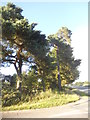
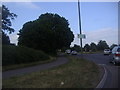
Trees on the corner of River Lane, Wrecclesham
Image: © David Howard
Taken: 3 Jul 2016
0.21 miles
2
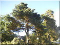
Trees on the corner of River Lane, Wrecclesham
Image: © David Howard
Taken: 3 Jul 2016
0.21 miles
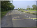
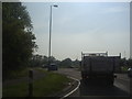
6
Wrecclesham Road before Farnham
The Coxbridge Roundabout on the A31 is just at the end.
Image: © David Howard
Taken: 14 Oct 2012
0.22 miles