IMAGES TAKEN NEAR TO
Runwick, FARNHAM, GU10 5EE
Introduction
This page details the photographs taken nearby to GU10 5EE by members of the Geograph project.
The Geograph project started in 2005 with the aim of publishing, organising and preserving representative images for every square kilometre of Great Britain, Ireland and the Isle of Man.

There are currently over 7.5m images from over14,400 individuals and you can help contribute to the project by visiting https://www.geograph.org.uk
Image Map
Images are licensed for reuse under creativecommons.org/licenses/by-sa/2.0
Notes
- Clicking on the map will re-center to the selected point.
- The higher the marker number, the further away the image location is from the centre of the postcode.
Image Listing (7 Images Found)
Images are licensed for reuse under creativecommons.org/licenses/by-sa/2.0
Image
Details
Distance
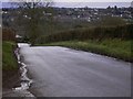
2
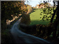
Clark's Hill
The lane south of Dippenhall crossing a small valley.
Image: © Andrew Smith
Taken: 18 Nov 2006
0.09 miles
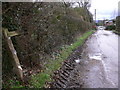
4
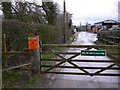
Split infinitive
This gate is at the entrance to Potts Farm on Runwick Lane.
Image: © Shazz
Taken: 26 Feb 2011
0.21 miles
6
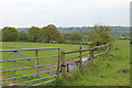
Footpath off Runwick Lane near Dippenhall
The farm ahead is Potts Farm.
Image: © Shazz
Taken: 26 Feb 2011
0.22 miles
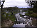
7
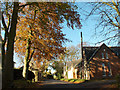
Dippenhall
On Clark's Hill, approaching the junction with Dippenhall Road.
Image: © Andrew Smith
Taken: 18 Nov 2006
0.23 miles