IMAGES TAKEN NEAR TO
Holmes Field Court, Main Road, FARNHAM, GU10 5DF
Introduction
This page details the photographs taken nearby to Holmes Field Court, Main Road, GU10 5DF by members of the Geograph project.
The Geograph project started in 2005 with the aim of publishing, organising and preserving representative images for every square kilometre of Great Britain, Ireland and the Isle of Man.

There are currently over 7.5m images from over14,400 individuals and you can help contribute to the project by visiting https://www.geograph.org.uk
Image Map
Images are licensed for reuse under creativecommons.org/licenses/by-sa/2.0
Notes
- Clicking on the map will re-center to the selected point.
- The higher the marker number, the further away the image location is from the centre of the postcode.
Image Listing (21 Images Found)
Images are licensed for reuse under creativecommons.org/licenses/by-sa/2.0
Image
Details
Distance
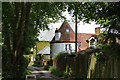
1
Oast House at Crocks Farm, Main Road, Bentley, Hampshire
Image: © Oast House Archive
Taken: 24 Jun 2009
0.02 miles
2
Oast House at Crocks Farm, Main Road, Bentley, Hampshire
Image: © Oast House Archive
Taken: 24 Jun 2009
0.02 miles
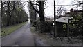
4
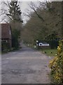
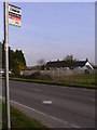
The drive to Pax Hill
There is a care home at Pax Hill.
Image: © Shazz
Taken: 17 Mar 2011
0.10 miles
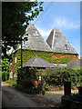
5
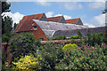
The Oast House, Bentley
'The Kilns' is also seen behind.
Image: © Oast House Archive
Taken: 19 May 2013
0.10 miles
9

Old Oasts at Bentley
This area once was rich in hop fields which supplied the former brewing industry in Alton and Farnham.
http://www.bentleyvillage.com/
Image: © Colin Smith
Taken: 30 May 2010
0.15 miles
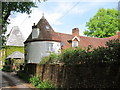
10
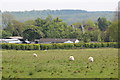
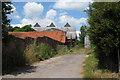
Field near Pax Hill
Top of The Kilns seen ahead.
Image: © Oast House Archive
Taken: 19 May 2013
0.16 miles