IMAGES TAKEN NEAR TO
Ewshot Lane, FARNHAM, GU10 5BP
Introduction
This page details the photographs taken nearby to Ewshot Lane, GU10 5BP by members of the Geograph project.
The Geograph project started in 2005 with the aim of publishing, organising and preserving representative images for every square kilometre of Great Britain, Ireland and the Isle of Man.

There are currently over 7.5m images from over14,400 individuals and you can help contribute to the project by visiting https://www.geograph.org.uk
Image Map
Images are licensed for reuse under creativecommons.org/licenses/by-sa/2.0
Notes
- Clicking on the map will re-center to the selected point.
- The higher the marker number, the further away the image location is from the centre of the postcode.
Image Listing (8 Images Found)
Images are licensed for reuse under creativecommons.org/licenses/by-sa/2.0
Image
Details
Distance
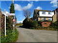
1
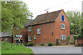
The Oast House, Ewshot Lane, Ewshot
Image: © Oast House Archive
Taken: 19 May 2013
0.19 miles
3
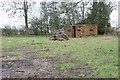
Ewshot, Hampshire
Disused Pillbox, now a wood store.
Image: © Brendan and Ruth McCartney
Taken: 27 Jan 2011
0.21 miles
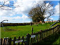
4
Village Hall and postbox in Ewshot
A picture from a year earlier is at http://www.geograph.org.uk/photo/3372328.
Image: © Shazz
Taken: 21 Mar 2014
0.22 miles
5

Ewshot - Village Hall
Wooden hall at the junction of Church and Tadpole Lanes.
www.ewshot.org.uk
Image: © Colin Smith
Taken: 9 Mar 2013
0.22 miles
6

Footpath from the north arrives at Ewshot
Information on the Sangs Project is at http://www.thesangsproject.co.uk/.
Image: © Shazz
Taken: 21 Mar 2014
0.22 miles
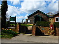
8
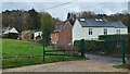
Ewshot Village Hall carpark
Houses on Tadpole Lane opposite Ewshot recreation ground.
Image: © James Emmans
Taken: 13 Dec 2021
0.24 miles