IMAGES TAKEN NEAR TO
Odiham Road, FARNHAM, GU10 5AB
Introduction
This page details the photographs taken nearby to Odiham Road, GU10 5AB by members of the Geograph project.
The Geograph project started in 2005 with the aim of publishing, organising and preserving representative images for every square kilometre of Great Britain, Ireland and the Isle of Man.

There are currently over 7.5m images from over14,400 individuals and you can help contribute to the project by visiting https://www.geograph.org.uk
Image Map
Images are licensed for reuse under creativecommons.org/licenses/by-sa/2.0
Notes
- Clicking on the map will re-center to the selected point.
- The higher the marker number, the further away the image location is from the centre of the postcode.
Image Listing (24 Images Found)
Images are licensed for reuse under creativecommons.org/licenses/by-sa/2.0
Image
Details
Distance
1
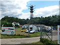
Amateur TV station, Odiham Road
Formerly a military radio installation, the main buildings are now home to an IT equipment refurbishment company. The interesting wooden mast, 26 m high, is now used by an amateur TV station, GB3HV - http://www.gb3hv.com/ . Apparently most of the antennae are now redundant.
Image: © Robin Webster
Taken: 30 Jul 2015
0.04 miles
2
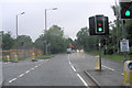
A287 becomes Odiham Road
The A3016 finishes here when it joins the A287 but the names of that road change too; from Folly Hill, coming in from the left, to Odiham Road straight ahead past the filling station.
Image: © Stuart Logan
Taken: 18 Aug 2011
0.05 miles
3
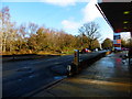
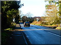
Odiham Road looking east
A similar picture is at http://www.geograph.org.uk/photo/20072. Fuel prices have increased a lot in the eight intervening years!
Image: © Shazz
Taken: 22 Dec 2013
0.05 miles
4
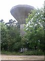
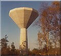
Water Tower
Water tower to the north of Farnham.
Image: © Ben Gamble
Taken: 19 Jun 2005
0.05 miles
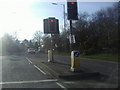
6
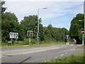
A287/A3016 junction
Traffic light junction at the northern edge of Farnham.
Image: © Ben Gamble
Taken: 19 Jun 2005
0.08 miles
8
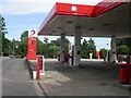
Old Park Service Station
On the A287 Odiham Road, Upper Hale, at the eastern edge of the square.
Image: © Ben Gamble
Taken: 19 Jun 2005
0.08 miles
9
A sunny day in Farnham
The lights at the junction of Upper Hale Road and Folly Hill, Hog Hatch
Image: © David Howard
Taken: 13 Mar 2011
0.09 miles
10
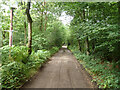
Old Park Lane
A public bridleway, also vehicle access to a few properties.
Image: © Robin Webster
Taken: 30 Jul 2015
0.09 miles