IMAGES TAKEN NEAR TO
Burnt Hill Road, FARNHAM, GU10 4RZ
Introduction
This page details the photographs taken nearby to Burnt Hill Road, GU10 4RZ by members of the Geograph project.
The Geograph project started in 2005 with the aim of publishing, organising and preserving representative images for every square kilometre of Great Britain, Ireland and the Isle of Man.

There are currently over 7.5m images from over14,400 individuals and you can help contribute to the project by visiting https://www.geograph.org.uk
Image Map
Images are licensed for reuse under creativecommons.org/licenses/by-sa/2.0
Notes
- Clicking on the map will re-center to the selected point.
- The higher the marker number, the further away the image location is from the centre of the postcode.
Image Listing (3 Images Found)
Images are licensed for reuse under creativecommons.org/licenses/by-sa/2.0
Image
Details
Distance
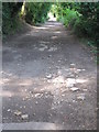
1
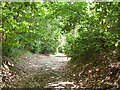
Twyford Lane
A short public byway traversable by ordinary car.
Image: © Robin Webster
Taken: 8 Aug 2015
0.17 miles
3
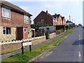
Little Green Lane, Wrecclesham
A village which has grown, and itself has been caught up in the suburban sprawl of Farnham.
Image: © Colin Smith
Taken: 31 Mar 2007
0.25 miles