IMAGES TAKEN NEAR TO
Bourne Dene, FARNHAM, GU10 4RF
Introduction
This page details the photographs taken nearby to Bourne Dene, GU10 4RF by members of the Geograph project.
The Geograph project started in 2005 with the aim of publishing, organising and preserving representative images for every square kilometre of Great Britain, Ireland and the Isle of Man.

There are currently over 7.5m images from over14,400 individuals and you can help contribute to the project by visiting https://www.geograph.org.uk
Image Map
Images are licensed for reuse under creativecommons.org/licenses/by-sa/2.0
Notes
- Clicking on the map will re-center to the selected point.
- The higher the marker number, the further away the image location is from the centre of the postcode.
Image Listing (7 Images Found)
Images are licensed for reuse under creativecommons.org/licenses/by-sa/2.0
Image
Details
Distance
4
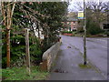
Bridge and footpath sign on Sandrock Hill Road
Across the way is a bridleway (see Image]).
Image: © Shazz
Taken: 26 Feb 2011
0.20 miles
6
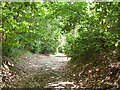
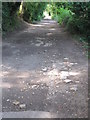
Twyford Lane
A short public byway traversable by ordinary car.
Image: © Robin Webster
Taken: 8 Aug 2015
0.21 miles
7
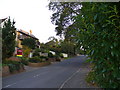
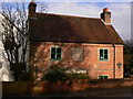
Sandrock Hill Road Boundstone
Residential area on the south-western edge of Farnham. Housing is quite upper class in this commuterland area.
Image: © Colin Smith
Taken: 4 Nov 2006
0.22 miles