IMAGES TAKEN NEAR TO
Kings Lane, FARNHAM, GU10 4QB
Introduction
This page details the photographs taken nearby to Kings Lane, GU10 4QB by members of the Geograph project.
The Geograph project started in 2005 with the aim of publishing, organising and preserving representative images for every square kilometre of Great Britain, Ireland and the Isle of Man.

There are currently over 7.5m images from over14,400 individuals and you can help contribute to the project by visiting https://www.geograph.org.uk
Image Map
Images are licensed for reuse under creativecommons.org/licenses/by-sa/2.0
Notes
- Clicking on the map will re-center to the selected point.
- The higher the marker number, the further away the image location is from the centre of the postcode.
Image Listing (73 Images Found)
Images are licensed for reuse under creativecommons.org/licenses/by-sa/2.0
Image
Details
Distance
1
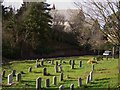
Burial site on School Hill in Wrecclesham
This was taken from the footpath.
Image: © Shazz
Taken: 26 Feb 2011
0.10 miles
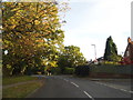
3
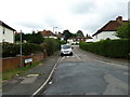
Looking from Greenfield Road into Cobbetts Way
Image: © Basher Eyre
Taken: 31 Jul 2010
0.13 miles
4
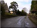
School Hill in Wrecclesham
To the left is St Peter's church and on the right is the lych gate to the burial ground.
Image: © Shazz
Taken: 26 Feb 2011
0.14 miles
5
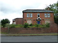
Derelict house opposite St Peter's Wrecclesham
Image: © Basher Eyre
Taken: 31 Jul 2010
0.14 miles
6
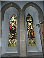
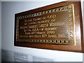
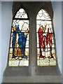
Wrecclesham, St Peter's: stained glass window (6)
Image: © Basher Eyre
Taken: 31 Jul 2010
0.14 miles
7
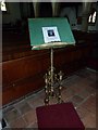
Wrecclesham, St Peter's: stained glass window (8)
Image: © Basher Eyre
Taken: 31 Jul 2010
0.14 miles
8
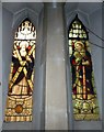
Wrecclesham, St Peter's: stained glass window (7)
Image: © Basher Eyre
Taken: 31 Jul 2010
0.15 miles