IMAGES TAKEN NEAR TO
Ellerton Way, FARNHAM, GU10 4NZ
Introduction
This page details the photographs taken nearby to Ellerton Way, GU10 4NZ by members of the Geograph project.
The Geograph project started in 2005 with the aim of publishing, organising and preserving representative images for every square kilometre of Great Britain, Ireland and the Isle of Man.

There are currently over 7.5m images from over14,400 individuals and you can help contribute to the project by visiting https://www.geograph.org.uk
Image Map
Images are licensed for reuse under creativecommons.org/licenses/by-sa/2.0
Notes
- Clicking on the map will re-center to the selected point.
- The higher the marker number, the further away the image location is from the centre of the postcode.
Image Listing (70 Images Found)
Images are licensed for reuse under creativecommons.org/licenses/by-sa/2.0
Image
Details
Distance
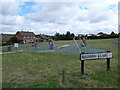
1
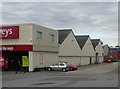
Grove Bell Industrial Estate
Small industrial estate on the edge of Farnham.
Image: © Ben Gamble
Taken: 6 Jul 2005
0.03 miles
2
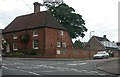
Wrecclesham House
No longer residential, but, in fact, offices in this Grade II listed building.
Image: © Ben Gamble
Taken: 6 Jul 2005
0.09 miles
3
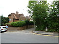
Junction of School Hill and Church Lane
Image: © Basher Eyre
Taken: 31 Jul 2010
0.09 miles
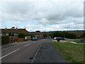
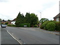
4
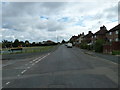
Junction of Beldham and Greenfield Roads
Image: © Basher Eyre
Taken: 31 Jul 2010
0.13 miles
6
Approaching the junction of Greenfield Road and Beldham Road
Image: © Basher Eyre
Taken: 31 Jul 2010
0.14 miles
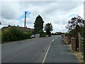
7
Wrecclesham Road before Farnham
The Coxbridge Roundabout on the A31 is just at the end.
Image: © David Howard
Taken: 14 Oct 2012
0.14 miles
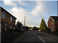
8
Looking from Beales Lane into Bryn Road
Image: © Basher Eyre
Taken: 31 Jul 2010
0.14 miles
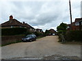
10
Approaching the junction of Greenfield Road and Weavers Gardens
Image: © Basher Eyre
Taken: 31 Jul 2010
0.15 miles