IMAGES TAKEN NEAR TO
The Street, FARNHAM, GU10 4HR
Introduction
This page details the photographs taken nearby to The Street, GU10 4HR by members of the Geograph project.
The Geograph project started in 2005 with the aim of publishing, organising and preserving representative images for every square kilometre of Great Britain, Ireland and the Isle of Man.

There are currently over 7.5m images from over14,400 individuals and you can help contribute to the project by visiting https://www.geograph.org.uk
Image Map
Images are licensed for reuse under creativecommons.org/licenses/by-sa/2.0
Notes
- Clicking on the map will re-center to the selected point.
- The higher the marker number, the further away the image location is from the centre of the postcode.
Image Listing (7 Images Found)
Images are licensed for reuse under creativecommons.org/licenses/by-sa/2.0
Image
Details
Distance
1
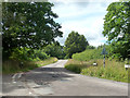
Change of road name
Pitt Lane to the east becomes The Street to the west at the junction with Old Lane on the left.
Image: © Robin Webster
Taken: 6 Aug 2015
0.07 miles
5
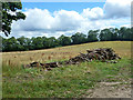
Timber stack near Dockenfield
Euroforest are responsible for this, according to the sign on the gate, although there is no forest in the immediate vicinity.
Image: © Robin Webster
Taken: 6 Aug 2015
0.20 miles
7
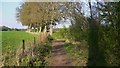
Footpath between fields near Dockenfield
At the bend in the path is a track to the right to Dockenfield Farm.
Image: © Shazz
Taken: 21 Apr 2009
0.25 miles