IMAGES TAKEN NEAR TO
Old Lane, FARNHAM, GU10 4HQ
Introduction
This page details the photographs taken nearby to Old Lane, GU10 4HQ by members of the Geograph project.
The Geograph project started in 2005 with the aim of publishing, organising and preserving representative images for every square kilometre of Great Britain, Ireland and the Isle of Man.

There are currently over 7.5m images from over14,400 individuals and you can help contribute to the project by visiting https://www.geograph.org.uk
Image Map
Images are licensed for reuse under creativecommons.org/licenses/by-sa/2.0
Notes
- Clicking on the map will re-center to the selected point.
- The higher the marker number, the further away the image location is from the centre of the postcode.
Image Listing (9 Images Found)
Images are licensed for reuse under creativecommons.org/licenses/by-sa/2.0
Image
Details
Distance
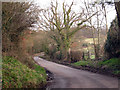
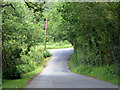
2
Old Lane at the junction of Heath Hill, Dockenfield
Image: © David Howard
Taken: 14 Oct 2012
0.08 miles
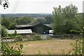
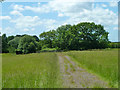
4
Shipwrights' Way 19
This is Holt Farm seen from Cradle Lane.
Image: © Shazz
Taken: 11 Oct 2013
0.13 miles
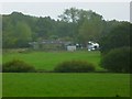
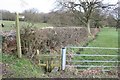
5
Sewage works
A track going to something in a fence which is mapped as a small sewage works. It may not be still functional - it looks very overgrown.
Image: © Robin Webster
Taken: 8 Jun 2014
0.15 miles
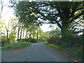
6
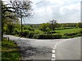
Junction of High Thicket Road and Old Lane
Image: © David Gearing
Taken: 23 Apr 2017
0.21 miles
7
Footpath to Dockenfield
Footpath from Old Lane to Dockenfield village
Image: © Richard Croft
Taken: 11 Mar 2008
0.22 miles
8
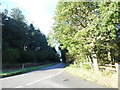
High Thicket Road at the junction of Old Lane
In Surrey looking at Hampshire
Image: © David Howard
Taken: 14 Oct 2012
0.23 miles
9
Steep descent to road junction
Old Lane drops down to meet High Thicket Road.
Image: © Robin Webster
Taken: 8 Jun 2014
0.23 miles