IMAGES TAKEN NEAR TO
Dockenfield, FARNHAM, GU10 4EY
Introduction
This page details the photographs taken nearby to GU10 4EY by members of the Geograph project.
The Geograph project started in 2005 with the aim of publishing, organising and preserving representative images for every square kilometre of Great Britain, Ireland and the Isle of Man.

There are currently over 7.5m images from over14,400 individuals and you can help contribute to the project by visiting https://www.geograph.org.uk
Image Map
Images are licensed for reuse under creativecommons.org/licenses/by-sa/2.0
Notes
- Clicking on the map will re-center to the selected point.
- The higher the marker number, the further away the image location is from the centre of the postcode.
Image Listing (17 Images Found)
Images are licensed for reuse under creativecommons.org/licenses/by-sa/2.0
Image
Details
Distance
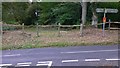
1
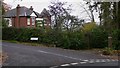
Road junction near Dockenfield
The house is on Boundary Road and Dockenfield Street is in the foreground. The picture shows Hampshire, very close to the Surrey border.
Image: © Shazz
Taken: 21 Oct 2009
0.06 miles
2
Approaching the junction of Dockenfield Street and High Thicket Road
Image: © David Gearing
Taken: 23 Apr 2017
0.09 miles
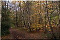
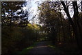
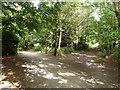
3
Footpath in Willow's Green Inclosure
The Inclosure is in Alice Holt Forest.
Image: © Shazz
Taken: 21 Oct 2009
0.10 miles
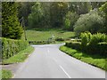
4
Abbotts Wood Inclosure viewed from Boundary Road
Dockenfield Street is the road going across the picture.
Image: © Shazz
Taken: 21 Oct 2009
0.11 miles
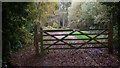
6
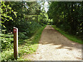
Footpath Binstead 51/3 in Alice Holt Forest
Towards Dockenfield Street. The red arrow signs a circular route within the Forestry Commission woodland.
Image: © Robin Webster
Taken: 30 Jul 2015
0.11 miles
7
Shipwrights' Way 13
Dockenfield Street comes into view. I took a picture here looking in the opposite direction four years ago - see http://www.geograph.org.uk/photo/1549389.
Image: © Shazz
Taken: 11 Oct 2013
0.11 miles
8
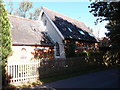
Former Bible Christian Chapel, Batts Corner
Erected in 1876. Now converted into a private residence.
Image: © Michael FORD
Taken: Unknown
0.12 miles
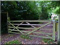
9
Path junction, Alice Holt Forest
In the Willow's Green Inclosure part of the Forestry Commission woodland.
Image: © Robin Webster
Taken: 30 Jul 2015
0.13 miles