IMAGES TAKEN NEAR TO
Recreation Road, FARNHAM, GU10 4BN
Introduction
This page details the photographs taken nearby to Recreation Road, GU10 4BN by members of the Geograph project.
The Geograph project started in 2005 with the aim of publishing, organising and preserving representative images for every square kilometre of Great Britain, Ireland and the Isle of Man.

There are currently over 7.5m images from over14,400 individuals and you can help contribute to the project by visiting https://www.geograph.org.uk
Image Map
Images are licensed for reuse under creativecommons.org/licenses/by-sa/2.0
Notes
- Clicking on the map will re-center to the selected point.
- The higher the marker number, the further away the image location is from the centre of the postcode.
Image Listing (17 Images Found)
Images are licensed for reuse under creativecommons.org/licenses/by-sa/2.0
Image
Details
Distance
1
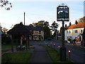
The Square, Rowledge
The village sign depicts cricketers (Rowledge has appeared in the village final at Lords). The village pub is the Hare and Hounds.
Image: © Colin Smith
Taken: 4 Nov 2006
0.05 miles
2
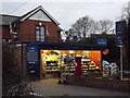
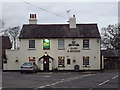
Best One, Rowledge
Village shop on The Square - with off licence, fruit, vegetables and post office too.
Image: © Colin Smith
Taken: 27 Dec 2011
0.06 miles
3
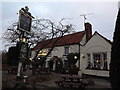
The Cherry Tree, Rowledge
Upmarket country pub in the village of Rowledge, south-west of Farnham.
Image: © Colin Smith
Taken: 27 Dec 2011
0.07 miles
4
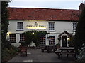
The Cherry Tree
Village inn at Rowledge with good food and a large paved patio.
Image: © Colin Smith
Taken: 27 Dec 2011
0.07 miles
5
Hare & Hounds
Welcoming lights in the pub on The Square at Rowledge.
Image: © Colin Smith
Taken: 27 Dec 2011
0.08 miles
6
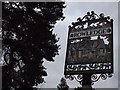
Rowledge
Village sign at The Square, Rowledge - showing cricketers, church, forest trees and animals.
Image: © Colin Smith
Taken: 27 Dec 2011
0.08 miles
7
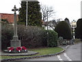
War Memorial, Rowledge
Outside "The Cherry Tree", at the east end of Church Lane.
www.rowledgechurch.com
Image: © Colin Smith
Taken: 27 Dec 2011
0.10 miles
8
Hampshire, Rowledge
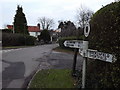
Despite what it says on the sign, most of this village lies within Surrey.
The Cherry Tree pub is visible in the distance.
Image: © Colin Smith
Taken: 27 Dec 2011
0.10 miles
9
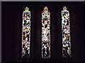
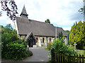
Rowledge, East Window
Inside St James, Rowledge's Victorian parish church.
www.rowledgechurch.com
Image: © Colin Smith
Taken: 27 Dec 2011
0.14 miles