IMAGES TAKEN NEAR TO
Boundstone Road, FARNHAM, GU10 4AU
Introduction
This page details the photographs taken nearby to Boundstone Road, GU10 4AU by members of the Geograph project.
The Geograph project started in 2005 with the aim of publishing, organising and preserving representative images for every square kilometre of Great Britain, Ireland and the Isle of Man.

There are currently over 7.5m images from over14,400 individuals and you can help contribute to the project by visiting https://www.geograph.org.uk
Image Map
Images are licensed for reuse under creativecommons.org/licenses/by-sa/2.0
Notes
- Clicking on the map will re-center to the selected point.
- The higher the marker number, the further away the image location is from the centre of the postcode.
Image Listing (5 Images Found)
Images are licensed for reuse under creativecommons.org/licenses/by-sa/2.0
Image
Details
Distance
1
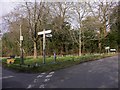
Waiting for the daffs
This small green in Rowledge has a lot of daffodils waiting to come into bloom.
Image: © Shazz
Taken: 3 Mar 2011
0.20 miles
2
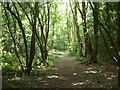
Woodland path to Switchback Lane
Most of this small rectangular wood is public access.
Image: © Robin Webster
Taken: 8 Aug 2015
0.22 miles
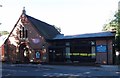
5
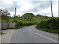
Marley Bridge Road at Marley Bridge Farm
Image: © David Gearing
Taken: 23 Apr 2017
0.24 miles