IMAGES TAKEN NEAR TO
Frensham Vale, FARNHAM, GU10 3HN
Introduction
This page details the photographs taken nearby to Frensham Vale, GU10 3HN by members of the Geograph project.
The Geograph project started in 2005 with the aim of publishing, organising and preserving representative images for every square kilometre of Great Britain, Ireland and the Isle of Man.

There are currently over 7.5m images from over14,400 individuals and you can help contribute to the project by visiting https://www.geograph.org.uk
Image Map
Images are licensed for reuse under creativecommons.org/licenses/by-sa/2.0
Notes
- Clicking on the map will re-center to the selected point.
- The higher the marker number, the further away the image location is from the centre of the postcode.
Image Listing (8 Images Found)
Images are licensed for reuse under creativecommons.org/licenses/by-sa/2.0
Image
Details
Distance
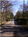
4
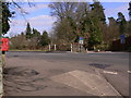
Crossroads on Frensham Road
Frensham Road is the A287. The picture is taken from Frensham Vale looking across to Latchwood Lane which has been made into a cul-de-sac by a barrier.
Image: © Shazz
Taken: 6 Mar 2011
0.10 miles
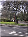
5
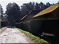
Forest Drive in Frensham
This cul-de-sac leads off Frensham Vale.
Image: © Shazz
Taken: 19 Mar 2011
0.12 miles
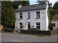
7
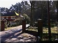
Entrance on Frensham Vale
This gateway is for Craig-Y-Barns.
Image: © Shazz
Taken: 19 Mar 2011
0.19 miles