IMAGES TAKEN NEAR TO
West End Lane, FARNHAM, GU10 3EP
Introduction
This page details the photographs taken nearby to West End Lane, GU10 3EP by members of the Geograph project.
The Geograph project started in 2005 with the aim of publishing, organising and preserving representative images for every square kilometre of Great Britain, Ireland and the Isle of Man.

There are currently over 7.5m images from over14,400 individuals and you can help contribute to the project by visiting https://www.geograph.org.uk
Image Map
Images are licensed for reuse under creativecommons.org/licenses/by-sa/2.0
Notes
- Clicking on the map will re-center to the selected point.
- The higher the marker number, the further away the image location is from the centre of the postcode.
Image Listing (8 Images Found)
Images are licensed for reuse under creativecommons.org/licenses/by-sa/2.0
Image
Details
Distance
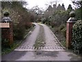
1
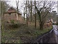
Disused building on West End Lane near Spreakley
Image: © Shazz
Taken: 3 Mar 2011
0.05 miles
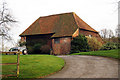
3
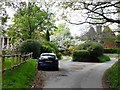
West End House and Oast House, West End Lane
Image: © David Gearing
Taken: 23 Apr 2017
0.19 miles
6
The Oast House, Woodhill Lane, Frensham, Surrey
Image: © Oast House Archive
Taken: 13 Mar 2009
0.22 miles
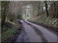
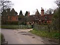
7
The Oast House, West End Lane, Rowledge, Surrey
Image: © Oast House Archive
Taken: 13 Mar 2009
0.23 miles
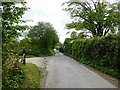
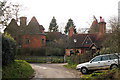
8
Houses on West End Lane
A similar picture was taken in 2009 (http://www.geograph.org.uk/photo/1202459).
Image: © Shazz
Taken: 3 Mar 2011
0.23 miles