IMAGES TAKEN NEAR TO
Priory Lane, FARNHAM, GU10 3DW
Introduction
This page details the photographs taken nearby to Priory Lane, GU10 3DW by members of the Geograph project.
The Geograph project started in 2005 with the aim of publishing, organising and preserving representative images for every square kilometre of Great Britain, Ireland and the Isle of Man.

There are currently over 7.5m images from over14,400 individuals and you can help contribute to the project by visiting https://www.geograph.org.uk
Image Map
Images are licensed for reuse under creativecommons.org/licenses/by-sa/2.0
Notes
- Clicking on the map will re-center to the selected point.
- The higher the marker number, the further away the image location is from the centre of the postcode.
Image Listing (19 Images Found)
Images are licensed for reuse under creativecommons.org/licenses/by-sa/2.0
Image
Details
Distance

2
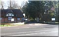
Gateway to Riverside House on Priory Lane, Millbridge
Image: © Shazz
Taken: 21 Apr 2009
0.06 miles
4

River Wey and garden seen from bridge on the A287
Image: © Shazz
Taken: 21 Apr 2009
0.07 miles
5
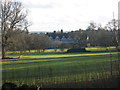
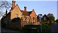
Pierrepont, Frensham
Grade II listed 19th century house. Pierrepont School until 1993, now Ellel Ministries.
Image: © David960
Taken: 2 Feb 2014
0.16 miles
6
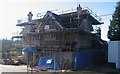
The Bridge at Pierrepont
Hotel previously known as Mariners.
Image: © David960
Taken: 19 Jan 2014
0.16 miles
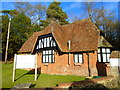
8
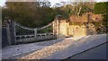
Ellel Pierrepont
Formerly the gateway of Pierrepont School.
Image: © David960
Taken: 19 Jan 2014
0.16 miles