IMAGES TAKEN NEAR TO
Frensham, FARNHAM, GU10 3BU
Introduction
This page details the photographs taken nearby to GU10 3BU by members of the Geograph project.
The Geograph project started in 2005 with the aim of publishing, organising and preserving representative images for every square kilometre of Great Britain, Ireland and the Isle of Man.

There are currently over 7.5m images from over14,400 individuals and you can help contribute to the project by visiting https://www.geograph.org.uk
Image Map
Images are licensed for reuse under creativecommons.org/licenses/by-sa/2.0
Notes
- Clicking on the map will re-center to the selected point.
- The higher the marker number, the further away the image location is from the centre of the postcode.
Image Listing (7 Images Found)
Images are licensed for reuse under creativecommons.org/licenses/by-sa/2.0
Image
Details
Distance
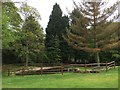
2
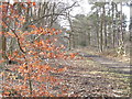
Bridleway on Farnham Heath
Paralleling The Reeds Road where some of the beech trees were planted way back in the 18th century.
Image: © Colin Smith
Taken: 22 Jan 2012
0.14 miles
3
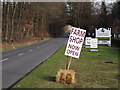
Farm Shop Now Open
At the Frensham Garden Centre on The Reeds Road, between Frensham and Tilford.
Image: © Colin Smith
Taken: 22 Jan 2012
0.15 miles
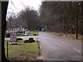
5
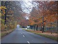
Frensham
Road by Frensham Garden Centre in Autumn
Image: © Ben Gamble
Taken: 21 Nov 2001
0.24 miles
6

Footbridge and ford at Tankersford
A track leads from Tilford across Tankersford Common and through Pierrepont Home Farm before crossing the River Wey at Tankersford. A footbridge has now been provided to save walkers from getting their feet wet.
Image: © Ron Strutt
Taken: 20 Nov 2004
0.24 miles