IMAGES TAKEN NEAR TO
Simmondstone Lane, FARNHAM, GU10 2QR
Introduction
This page details the photographs taken nearby to Simmondstone Lane, GU10 2QR by members of the Geograph project.
The Geograph project started in 2005 with the aim of publishing, organising and preserving representative images for every square kilometre of Great Britain, Ireland and the Isle of Man.

There are currently over 7.5m images from over14,400 individuals and you can help contribute to the project by visiting https://www.geograph.org.uk
Image Map
Images are licensed for reuse under creativecommons.org/licenses/by-sa/2.0
Notes
- Clicking on the map will re-center to the selected point.
- The higher the marker number, the further away the image location is from the centre of the postcode.
Image Listing (9 Images Found)
Images are licensed for reuse under creativecommons.org/licenses/by-sa/2.0
Image
Details
Distance
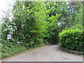
1
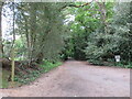
Public bridleway, Churt, near Farnham
A public bridleway along a driveway on the edge of the village of Churt, in Surrey. This location is very close to the border with Hampshire.
Image: © Malc McDonald
Taken: 20 May 2023
0.14 miles
2
Star Hill Drive, Churt, near Farnham
Star Hill Drive is a residential cul-de-sac on the edge of the village of Churt in Surrey.
Image: © Malc McDonald
Taken: 20 May 2023
0.16 miles
3
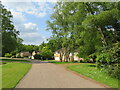
Star Hill Drive, Churt, near Farnham
Star Hill Drive is a residential cul-de-sac on the edge of the village of Churt in Surrey.
Image: © Malc McDonald
Taken: 20 May 2023
0.16 miles
5
Lampard Lane, Churt, near Farnham
Lampard Lane is a minor lane on the edge of the Surrey village of Churt, very close to the border with Hampshire.
Image: © Malc McDonald
Taken: 20 May 2023
0.19 miles
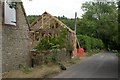
6
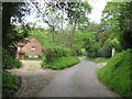
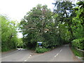
Wishanger Lane, near Farnham
Wishanger Lane is a minor road through countryside on the borders of Hampshire and Surrey. Here the lane passes a house on the Hampshire side of the border. The lane will cross into Surrey about 200 metres further ahead.
Image: © Malc McDonald
Taken: 20 May 2023
0.19 miles
7
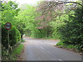
Star Hill, Churt, near Farnham
Star Hill is a minor road on the edge of the village of Churt, in Surrey. Here, the road approaches a junction with the A287. The sign to the left of the image is a "repeater" sign reminding motorists that a speed limit of 50 miles per hour applies here.
Image: © Malc McDonald
Taken: 20 May 2023
0.23 miles
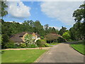
8
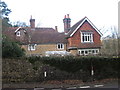
Threeways, Churt
Large house at the junction of Farnham Road and Star Hill. Once the site of the Star Inn.
Image: © David960
Taken: 2 Feb 2014
0.24 miles
9
Road junction in Churt, near Farnham
A road junction on the edge of the village of Churt in Surrey. The road to the left is the A287.
Image: © Malc McDonald
Taken: 20 May 2023
0.24 miles