IMAGES TAKEN NEAR TO
Churt Road, FARNHAM, GU10 2NX
Introduction
This page details the photographs taken nearby to Churt Road, GU10 2NX by members of the Geograph project.
The Geograph project started in 2005 with the aim of publishing, organising and preserving representative images for every square kilometre of Great Britain, Ireland and the Isle of Man.

There are currently over 7.5m images from over14,400 individuals and you can help contribute to the project by visiting https://www.geograph.org.uk
Image Map
Images are licensed for reuse under creativecommons.org/licenses/by-sa/2.0
Notes
- Clicking on the map will re-center to the selected point.
- The higher the marker number, the further away the image location is from the centre of the postcode.
Image Listing (52 Images Found)
Images are licensed for reuse under creativecommons.org/licenses/by-sa/2.0
Image
Details
Distance
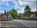
1
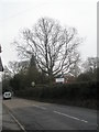
Looking south-east on the A287 in Churt village centre
Image: © Basher Eyre
Taken: 6 Feb 2010
0.07 miles
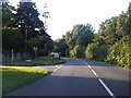
4
Green Lane meets Churt Road
30 mph on most of Green Lane would be pushing it, here is a welcome increase to 30 mph on the A287.
Image: © Robin Webster
Taken: 18 Feb 2015
0.11 miles
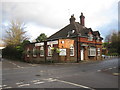
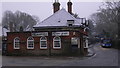
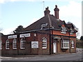
6
The Crossways Inn
Prominent inn on the main crossroads in Churt village centre.
http://en.wikipedia.org/wiki/Churt
Image: © Colin Smith
Taken: 18 Mar 2012
0.11 miles
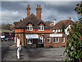
7
The Crossways Inn, Churt
Long-established village inn on the main crossroads of Churt.
http://en.wikipedia.org/wiki/Churt
Image: © Colin Smith
Taken: 18 Mar 2012
0.12 miles
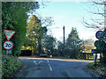
8
Looking across the A287 into Barford Lane
Image: © Basher Eyre
Taken: 6 Feb 2010
0.12 miles
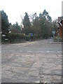
9
Junction for Crossways, Hale House Lane and Barford Lane
Image: © Basher Eyre
Taken: 7 May 2024
0.13 miles
10
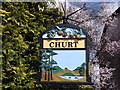
Welcome to Churt
Colourful village sign below compass points at the Crossways. The sign shows local items of historical interest - apples, pine trees, Frensham Pond and the Devil's Jumps.
http://en.wikipedia.org/wiki/Churt
Image: © Colin Smith
Taken: 18 Mar 2012
0.13 miles