IMAGES TAKEN NEAR TO
Green Lane, FARNHAM, GU10 2NB
Introduction
This page details the photographs taken nearby to Green Lane, GU10 2NB by members of the Geograph project.
The Geograph project started in 2005 with the aim of publishing, organising and preserving representative images for every square kilometre of Great Britain, Ireland and the Isle of Man.

There are currently over 7.5m images from over14,400 individuals and you can help contribute to the project by visiting https://www.geograph.org.uk
Image Map
Images are licensed for reuse under creativecommons.org/licenses/by-sa/2.0
Notes
- Clicking on the map will re-center to the selected point.
- The higher the marker number, the further away the image location is from the centre of the postcode.
Image Listing (14 Images Found)
Images are licensed for reuse under creativecommons.org/licenses/by-sa/2.0
Image
Details
Distance
1
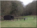
Dry Valley by Willow Farm
Grassy fields and stable in a valley bottom at Churt.
http://en.wikipedia.org/wiki/Churt
Image: © Colin Smith
Taken: 18 Mar 2012
0.07 miles
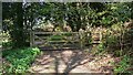
2
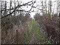
Footpath by Green Lane
Fenced footpath in an established fruit growing area close to Churt.
http://en.wikipedia.org/wiki/Churt
Image: © Colin Smith
Taken: 18 Mar 2012
0.07 miles
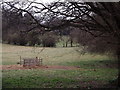
3
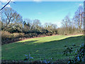
Field by Green Lane
In the angle of the lane, which is the viewpoint and also behind the hedge on the left.
Image: © Robin Webster
Taken: 18 Feb 2015
0.10 miles
4
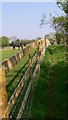
Footpath from Green Lane to Old Barn Lane
This land was an orchard but has now been made into paddocks. Some of the old orchard trees are on the right of the path.
Image: © Shazz
Taken: 19 Apr 2009
0.12 miles
5
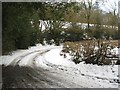
Green Lane, Churt
With steep hills on either side of this spot, not much traffic gets through in the snow.
Image: © Ben Gamble
Taken: 7 Feb 2009
0.13 miles
6
Footpath arrives at Green Lane north of Beacon Hill
Image: © Shazz
Taken: 19 Apr 2009
0.17 miles
7
Field by Green Cross Farm
Pastoral landscape of fields and hedgerows by Churt.
http://en.wikipedia.org/wiki/Churt
Image: © Colin Smith
Taken: 18 Mar 2012
0.20 miles
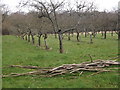
8
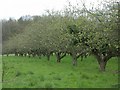
Orchard
Taken from 869380, looking north from the footpath
Image: © Ben Gamble
Taken: 16 Apr 2005
0.20 miles
9
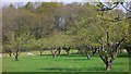
Orchard north of Beacon Hill
Since the first geograph was taken four years ago the trees have been thinned out and there are now grazing stock beyond
http://www.geograph.org.uk/photo/3846.
Image: © Shazz
Taken: 19 Apr 2009
0.20 miles
10
By Applegarth Farm
Apple orchard by Old Barn Lane, south-east of Chuert. Fruit growing is an established industry here.
http://en.wikipedia.org/wiki/Churt
Image: © Colin Smith
Taken: 18 Mar 2012
0.20 miles