IMAGES TAKEN NEAR TO
Old Kiln Lane, FARNHAM, GU10 2JL
Introduction
This page details the photographs taken nearby to Old Kiln Lane, GU10 2JL by members of the Geograph project.
The Geograph project started in 2005 with the aim of publishing, organising and preserving representative images for every square kilometre of Great Britain, Ireland and the Isle of Man.

There are currently over 7.5m images from over14,400 individuals and you can help contribute to the project by visiting https://www.geograph.org.uk
Image Map
Images are licensed for reuse under creativecommons.org/licenses/by-sa/2.0
Notes
- Clicking on the map will re-center to the selected point.
- The higher the marker number, the further away the image location is from the centre of the postcode.
Image Listing (4 Images Found)
Images are licensed for reuse under creativecommons.org/licenses/by-sa/2.0
Image
Details
Distance
2
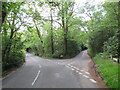
Road junction near Farnham
A junction of minor roads in woodland, near the Surrey village of Churt.
Image: © Malc McDonald
Taken: 20 May 2023
0.08 miles
3
Jumps Road
Named after the Devil's Jumps, three hills which lie some way to the north of the road.
Image: © Robin Webster
Taken: 18 Feb 2015
0.17 miles
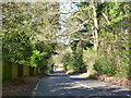
4

Crosswater Lane
Cul-de-sac for motorists with large houses hidden away behind hedges and trees.
Image: © Colin Smith
Taken: 18 Oct 2008
0.22 miles