IMAGES TAKEN NEAR TO
Lowicks Road, FARNHAM, GU10 2EY
Introduction
This page details the photographs taken nearby to Lowicks Road, GU10 2EY by members of the Geograph project.
The Geograph project started in 2005 with the aim of publishing, organising and preserving representative images for every square kilometre of Great Britain, Ireland and the Isle of Man.

There are currently over 7.5m images from over14,400 individuals and you can help contribute to the project by visiting https://www.geograph.org.uk
Image Map
Images are licensed for reuse under creativecommons.org/licenses/by-sa/2.0
Notes
- Clicking on the map will re-center to the selected point.
- The higher the marker number, the further away the image location is from the centre of the postcode.
Image Listing (5 Images Found)
Images are licensed for reuse under creativecommons.org/licenses/by-sa/2.0
Image
Details
Distance
1
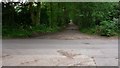
Wellesley Road in Rushmoor
This is the view west from the crossing of Eglinton Road. The whole of Wellesley Road is unmade.
Image: © Shazz
Taken: 12 Jun 2009
0.14 miles
2
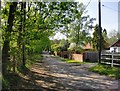
Sandy Lane, Rushmoor
Residential development on the right (mostly post-1960), woodland on the left (mostly conifers).
Image: © Stefan Czapski
Taken: 13 May 2016
0.15 miles
3
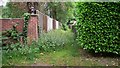
Overgrown twitten off Wellesley Road in Rushmoor
This is opposite the Water Treatment Works. I don't know whether it is for private or public use.
Image: © Shazz
Taken: 12 Jun 2009
0.20 miles
4
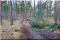
Branches on the Bridleway
Woodland ride near Rushmoor.
Image: © Des Blenkinsopp
Taken: 1 Feb 2018
0.24 miles
5
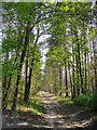
Woodland track leading south from Sandy Lane, Rushmoor
Image: © Stefan Czapski
Taken: 13 May 2016
0.24 miles