IMAGES TAKEN NEAR TO
Sandy Lane, FARNHAM, GU10 2EX
Introduction
This page details the photographs taken nearby to Sandy Lane, GU10 2EX by members of the Geograph project.
The Geograph project started in 2005 with the aim of publishing, organising and preserving representative images for every square kilometre of Great Britain, Ireland and the Isle of Man.

There are currently over 7.5m images from over14,400 individuals and you can help contribute to the project by visiting https://www.geograph.org.uk
Image Map
Images are licensed for reuse under creativecommons.org/licenses/by-sa/2.0
Notes
- Clicking on the map will re-center to the selected point.
- The higher the marker number, the further away the image location is from the centre of the postcode.
Image Listing (16 Images Found)
Images are licensed for reuse under creativecommons.org/licenses/by-sa/2.0
Image
Details
Distance
1
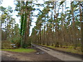
Passing Lowicks on a path through Frensham Common
Image: © Basher Eyre
Taken: 12 Feb 2018
0.03 miles
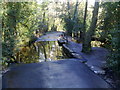
4
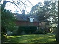
Grey Walls
At the end of Sandy Lane, Rushmoor.
Image: © David960
Taken: 8 Mar 2014
0.13 miles
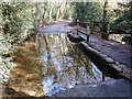
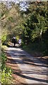
6
Ford at Frensham Common
This flagged bottom ford is found at Grey Walls on Sandy Lane.
Image: © John Walton
Taken: 10 Nov 2013
0.16 miles
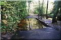
7
Sandy Lane
Ford near the end of Sandy Lane, Rushmoor, at SU861406.
Image: © Ben Gamble
Taken: 11 Jun 2005
0.16 miles
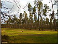
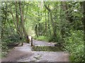
9
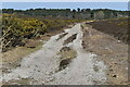
Sandy path on Frensham Common
The entire common is criss-crossed by sandy paths like this one.
Image: © David Martin
Taken: 24 Apr 2021
0.18 miles
10
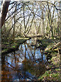
Stream flowing towards Frensham Little Pond
There is a considerable area of wooded swamp here.
Image: © Robin Webster
Taken: 18 Feb 2015
0.19 miles