IMAGES TAKEN NEAR TO
Tilford Road, FARNHAM, GU10 2EN
Introduction
This page details the photographs taken nearby to Tilford Road, GU10 2EN by members of the Geograph project.
The Geograph project started in 2005 with the aim of publishing, organising and preserving representative images for every square kilometre of Great Britain, Ireland and the Isle of Man.

There are currently over 7.5m images from over14,400 individuals and you can help contribute to the project by visiting https://www.geograph.org.uk
Image Map
Images are licensed for reuse under creativecommons.org/licenses/by-sa/2.0
Notes
- Clicking on the map will re-center to the selected point.
- The higher the marker number, the further away the image location is from the centre of the postcode.
Image Listing (9 Images Found)
Images are licensed for reuse under creativecommons.org/licenses/by-sa/2.0
Image
Details
Distance
1
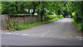
Looking west along Lowicks Road from Tilford Road in Rushmoor
Image: © Shazz
Taken: 12 Jun 2009
0.09 miles
2
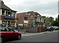
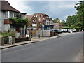
Rushmoor
The Post Office, country store and garage which make up the total retail experience of the village of Rushmoor.
Image: © Ben Gamble
Taken: 11 Jun 2005
0.12 miles
3
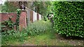
Overgrown twitten off Wellesley Road in Rushmoor
This is opposite the Water Treatment Works. I don't know whether it is for private or public use.
Image: © Shazz
Taken: 12 Jun 2009
0.17 miles
4
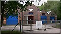
Waterworks at Rushmoor in Surrey
The building is in Wellesley Road but the notice on the gate proclaims it to be in Wesley Road!
Image: © Shazz
Taken: 12 Jun 2009
0.18 miles
5
Rushmoor post office
The post office on Tilford Road in Rushmoor.
Image: © Alan Hunt
Taken: 22 Jun 2014
0.18 miles
6
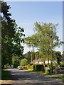
Sandy Lane, Rushmoor: southern end
Looking north-west from near the southern end of Sandy Lane, just off the Hindhead-Tilford road. There is 20th-century residential development on both sides, so that the character of the area is somewhat suburban.
A couple of hundred yards ahead, Sandy Lane dog-legs to the left, in a more westerly direction.
Image: © Stefan Czapski
Taken: 13 May 2016
0.19 miles
7
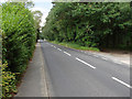
Tilford Road, Rushmoor
The Tilford Road running north through the rural settlement of Rushmoor.
Image: © Alan Hunt
Taken: 22 Jun 2014
0.23 miles
8

Gold Hill, Hankley Common
The path up Gold Hill, a high spot on the western edge of Hankley Common.
Image: © Alan Hunt
Taken: 22 Jun 2014
0.24 miles
9

Pine woods, Hankly Common
A path through the pine woods on the western side of Hankley Common.
Image: © Alan Hunt
Taken: 22 Jun 2014
0.25 miles