IMAGES TAKEN NEAR TO
Swifts Close, FARNHAM, GU10 1QX
Introduction
This page details the photographs taken nearby to Swifts Close, GU10 1QX by members of the Geograph project.
The Geograph project started in 2005 with the aim of publishing, organising and preserving representative images for every square kilometre of Great Britain, Ireland and the Isle of Man.

There are currently over 7.5m images from over14,400 individuals and you can help contribute to the project by visiting https://www.geograph.org.uk
Image Map
Images are licensed for reuse under creativecommons.org/licenses/by-sa/2.0
Notes
- Clicking on the map will re-center to the selected point.
- The higher the marker number, the further away the image location is from the centre of the postcode.
Image Listing (20 Images Found)
Images are licensed for reuse under creativecommons.org/licenses/by-sa/2.0
Image
Details
Distance
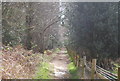
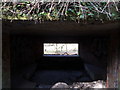
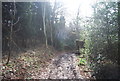
4
Underground bunker, Moor Park
Part of the GHQ line from WWII.
Image: © N Chadwick
Taken: 14 Apr 2013
0.13 miles
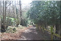
5
Pillbox on the Greensand Way
One of the many in this area, relics of World War 2.
Image: © Diane Sambrook
Taken: 22 Mar 2009
0.14 miles
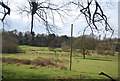
6
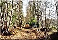
Greensand Way south-east of Farnham
This part of the Greensand Way follows the course of the River Wey whose meadows can just be made out on the right.
Image: © David Kemp
Taken: 17 Dec 2006
0.14 miles
7
Blossoms on Compton Way
These are azaleas or rhododendrons but I'm no good at telling one from the other. Anyway they were the first I saw this year and they pleased me greatly.
Image: © Shazz
Taken: 6 Mar 2011
0.14 miles
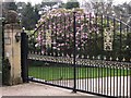
8
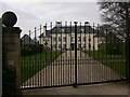
Chateau on Compton Way
Well, it looks like a chateau to me.
Image: © Shazz
Taken: 6 Mar 2011
0.16 miles
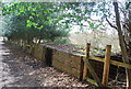
10
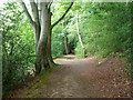
Terrace footpath
This follows the River Wey (Northern Branch) a comfortable height above the soggier parts of the valley.
Image: © Robin Webster
Taken: 8 Aug 2015
0.18 miles