IMAGES TAKEN NEAR TO
Crooksbury Road, FARNHAM, GU10 1QE
Introduction
This page details the photographs taken nearby to Crooksbury Road, GU10 1QE by members of the Geograph project.
The Geograph project started in 2005 with the aim of publishing, organising and preserving representative images for every square kilometre of Great Britain, Ireland and the Isle of Man.

There are currently over 7.5m images from over14,400 individuals and you can help contribute to the project by visiting https://www.geograph.org.uk
Image Map
Images are licensed for reuse under creativecommons.org/licenses/by-sa/2.0
Notes
- Clicking on the map will re-center to the selected point.
- The higher the marker number, the further away the image location is from the centre of the postcode.
Image Listing (41 Images Found)
Images are licensed for reuse under creativecommons.org/licenses/by-sa/2.0
Image
Details
Distance
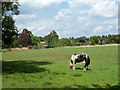
7
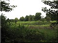
Lone horse
The horse is tethered in the middle of the field.
Image: © don cload
Taken: 4 Oct 2011
0.12 miles
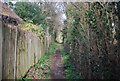
8
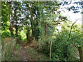
Footpath, Runfold
From Crooksbury Road to Guildford Road.
Image: © Robin Webster
Taken: 8 Aug 2015
0.12 miles
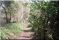
9
Grazing horse, Runfold
A bridleway forms the western boundary of this field.
Image: © Robin Webster
Taken: 8 Aug 2015
0.14 miles
10
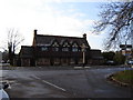
The Jolly Farmer Runfold
This pub is on the old A31 now bypassed as part of the road improvements around the end of the Hogs Back. The roads still jam up, the pub has less trade!
Image: © Graham Clutton
Taken: 28 Dec 2005
0.14 miles