IMAGES TAKEN NEAR TO
Blighton Lane, FARNHAM, GU10 1PT
Introduction
This page details the photographs taken nearby to Blighton Lane, GU10 1PT by members of the Geograph project.
The Geograph project started in 2005 with the aim of publishing, organising and preserving representative images for every square kilometre of Great Britain, Ireland and the Isle of Man.

There are currently over 7.5m images from over14,400 individuals and you can help contribute to the project by visiting https://www.geograph.org.uk
Image Map
Images are licensed for reuse under creativecommons.org/licenses/by-sa/2.0
Notes
- Clicking on the map will re-center to the selected point.
- The higher the marker number, the further away the image location is from the centre of the postcode.
Image Listing (6 Images Found)
Images are licensed for reuse under creativecommons.org/licenses/by-sa/2.0
Image
Details
Distance
1
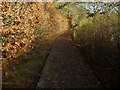
A useful raised path on the North Downs Way
Once the path stops the mud begins.
Image: © Shazz
Taken: 8 Dec 2012
0.03 miles
2
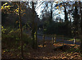
Blighton Lane
The North Downs Way joins Blighton Lane with a wooden bridge over the roadside ditch.
Image: © Robert Eva
Taken: 29 Nov 2016
0.06 miles
3
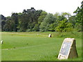
Next Stop, 19th Hole
The 18th tee at Farnham Golf Club is adjacent to the North Downs Way.
http://www.farnhamgolfclub.co.uk/pages.php/index.html
Image: © Colin Smith
Taken: 23 May 2009
0.08 miles

6

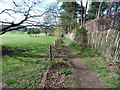
North Downs way near The Sands
This looks like it is part of Farnham Golf Club
Image: © Robert Eva
Taken: 29 Nov 2016
0.19 miles