IMAGES TAKEN NEAR TO
Tongham Road, FARNHAM, GU10 1PH
Introduction
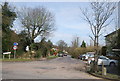
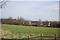
This page details the photographs taken nearby to Tongham Road, GU10 1PH by members of the Geograph project.
The Geograph project started in 2005 with the aim of publishing, organising and preserving representative images for every square kilometre of Great Britain, Ireland and the Isle of Man.

There are currently over 7.5m images from over14,400 individuals and you can help contribute to the project by visiting https://www.geograph.org.uk
Image Map
Images are licensed for reuse under creativecommons.org/licenses/by-sa/2.0
Notes
- Clicking on the map will re-center to the selected point.
- The higher the marker number, the further away the image location is from the centre of the postcode.
Image Listing (44 Images Found)
Images are licensed for reuse under creativecommons.org/licenses/by-sa/2.0
Image
Details
Distance
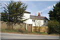
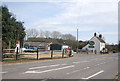
6
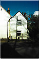
Former Toll House, Guildford Road, Runfold
400 Yds South of the current version of the A31. This Toll House served the Guildford & Farnham Turnpike Trust in the 19ᵗʰ C. An alternative view from 2013 is Image
In the 1861 census, the gatekeeper was listed as Edward Bartholomew
Milestone Society National ID: SY.FAR
Image: © Janet Dowding
Taken: 22 Aug 2024
0.06 miles
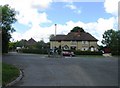
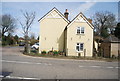
7
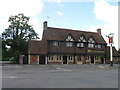
Kei's Peking Restaurant, formerly The Jolly Farmer
Image: © Alex McGregor
Taken: 9 Jun 2011
0.07 miles