IMAGES TAKEN NEAR TO
Guildford Road, FARNHAM, GU10 1NZ
Introduction
This page details the photographs taken nearby to Guildford Road, GU10 1NZ by members of the Geograph project.
The Geograph project started in 2005 with the aim of publishing, organising and preserving representative images for every square kilometre of Great Britain, Ireland and the Isle of Man.

There are currently over 7.5m images from over14,400 individuals and you can help contribute to the project by visiting https://www.geograph.org.uk
Image Map
Images are licensed for reuse under creativecommons.org/licenses/by-sa/2.0
Notes
- Clicking on the map will re-center to the selected point.
- The higher the marker number, the further away the image location is from the centre of the postcode.
Image Listing (4 Images Found)
Images are licensed for reuse under creativecommons.org/licenses/by-sa/2.0
Image
Details
Distance
1
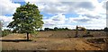
Construction works off Rock House Lane
Image: © Oast House Archive
Taken: 7 Sep 2018
0.09 miles
2
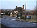
Princess Royal Pub near Runfold
this pub is on a section of the A31 now bypassed by road improvements around the west end of the Hogs Back.
Image: © Graham Clutton
Taken: 28 Dec 2005
0.11 miles
3
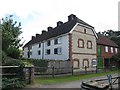
Oast house at Kilnside Farm, Moor Park Lane, Runfold
Image: © Oast House Archive
Taken: 7 Sep 2018
0.20 miles
4
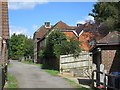
Oast house at Kilnside Farm, Moor Park Lane, Runfold
Image: © Oast House Archive
Taken: 7 Sep 2018
0.21 miles