IMAGES TAKEN NEAR TO
Long Hill, FARNHAM, GU10 1NQ
Introduction
This page details the photographs taken nearby to Long Hill, GU10 1NQ by members of the Geograph project.
The Geograph project started in 2005 with the aim of publishing, organising and preserving representative images for every square kilometre of Great Britain, Ireland and the Isle of Man.

There are currently over 7.5m images from over14,400 individuals and you can help contribute to the project by visiting https://www.geograph.org.uk
Image Map
Images are licensed for reuse under creativecommons.org/licenses/by-sa/2.0
Notes
- Clicking on the map will re-center to the selected point.
- The higher the marker number, the further away the image location is from the centre of the postcode.
Image Listing (3 Images Found)
Images are licensed for reuse under creativecommons.org/licenses/by-sa/2.0
Image
Details
Distance
1
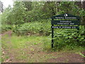
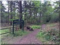
Entering Crooksbury Common
From the end of Long Hill, coming out of The Sands into Forestry Commission land and fine walking country. Unless it is a variant, the name should probably be spelled Crooksbury.
Image: © Colin Smith
Taken: 16 Jun 2012
0.14 miles
3
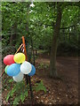
Party Time
A clutch of bright balloons at the end of Crooksbury Lane in The Sands.
Image: © Colin Smith
Taken: 16 Jun 2012
0.16 miles