IMAGES TAKEN NEAR TO
Botany Hill, FARNHAM, GU10 1LZ
Introduction
This page details the photographs taken nearby to Botany Hill, GU10 1LZ by members of the Geograph project.
The Geograph project started in 2005 with the aim of publishing, organising and preserving representative images for every square kilometre of Great Britain, Ireland and the Isle of Man.

There are currently over 7.5m images from over14,400 individuals and you can help contribute to the project by visiting https://www.geograph.org.uk
Image Map
Images are licensed for reuse under creativecommons.org/licenses/by-sa/2.0
Notes
- Clicking on the map will re-center to the selected point.
- The higher the marker number, the further away the image location is from the centre of the postcode.
Image Listing (19 Images Found)
Images are licensed for reuse under creativecommons.org/licenses/by-sa/2.0
Image
Details
Distance
7
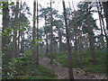
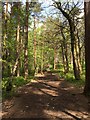
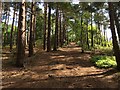
Soldiers Ring, Crooksbury Hill
Ancient earthwork which is well hidden in the pinewood. The sandy soils of the hill are evident in the many bridle paths here.
Image: © Colin Smith
Taken: 31 Mar 2007
0.19 miles
9
Steep path to the summit of Crooksbury Hill
Image: © don cload
Taken: 15 May 2016
0.19 miles