IMAGES TAKEN NEAR TO
Seale Lane, FARNHAM, GU10 1LE
Introduction
This page details the photographs taken nearby to Seale Lane, GU10 1LE by members of the Geograph project.
The Geograph project started in 2005 with the aim of publishing, organising and preserving representative images for every square kilometre of Great Britain, Ireland and the Isle of Man.

There are currently over 7.5m images from over14,400 individuals and you can help contribute to the project by visiting https://www.geograph.org.uk
Image Map
Images are licensed for reuse under creativecommons.org/licenses/by-sa/2.0
Notes
- Clicking on the map will re-center to the selected point.
- The higher the marker number, the further away the image location is from the centre of the postcode.
Image Listing (8 Images Found)
Images are licensed for reuse under creativecommons.org/licenses/by-sa/2.0
Image
Details
Distance
1
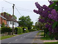
Seale Lane
Quiet residential hamlet between Runsfold and Seale, south of the Hog's Back's west end.
Image: © Colin Smith
Taken: 23 May 2009
0.01 miles
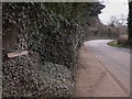
2
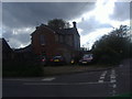
House on the corner of Blighton Lane and Seale Lane
Image: © David Howard
Taken: 7 May 2012
0.13 miles
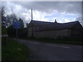
4
House at the corner of Blighton Lane
Built of both brick and clunch (meaning chalk).
Image: © Stefan Czapski
Taken: 10 Dec 2014
0.14 miles
5
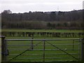
Fields near Runfold Manor
In the distance is the mast by Smugglers Way - see Image
Image: © Shazz
Taken: 6 Mar 2011
0.19 miles
7
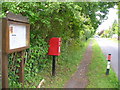
Sandy Cross
Village notice board for Seale and Sands Parish Council with a modern post box on Seale Lane in this quiet hamlet.
Image: © Colin Smith
Taken: 23 May 2009
0.24 miles
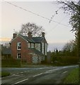
8
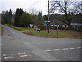
Sandy Cross near Seale
This would have been a more major cross roads in the past but the road behind is now a cul-de-sac thanks to the A 31
Image: © Graham Clutton
Taken: 6 Jan 2006
0.24 miles