IMAGES TAKEN NEAR TO
Elstead Road, FARNHAM, GU10 1JH
Introduction
This page details the photographs taken nearby to Elstead Road, GU10 1JH by members of the Geograph project.
The Geograph project started in 2005 with the aim of publishing, organising and preserving representative images for every square kilometre of Great Britain, Ireland and the Isle of Man.

There are currently over 7.5m images from over14,400 individuals and you can help contribute to the project by visiting https://www.geograph.org.uk
Image Map
Images are licensed for reuse under creativecommons.org/licenses/by-sa/2.0
Notes
- Clicking on the map will re-center to the selected point.
- The higher the marker number, the further away the image location is from the centre of the postcode.
Image Listing (39 Images Found)
Images are licensed for reuse under creativecommons.org/licenses/by-sa/2.0
Image
Details
Distance
1
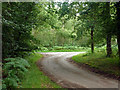
Lane towards Littleworth Road
The lane from the drive into the Hampton Estate forms a triangular junction here, this is the westwards branch.
Image: © Robin Webster
Taken: 20 Jul 2012
0.08 miles
2
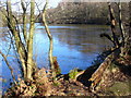
Warren Pond
Frozen and tree-fringed pond, one of a series of medieval ponds created for holding fish stocks.
Image: © Colin Smith
Taken: 30 Jan 2010
0.10 miles
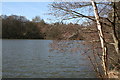
3
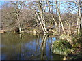
The Tarn
One of a series of medieval "stew" ponds in a side valley of the Wey. These have been built for keeping fish stocks. In the distance is the next pond up the valley, Warren Pond.
Image: © Colin Smith
Taken: 30 Jan 2010
0.10 miles
4
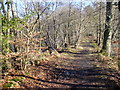
Footpath to Puttenham Common
Crossing between Warren Pond (left) and The Tarn (right), two ponds created for fish stocks.
Image: © Colin Smith
Taken: 30 Jan 2010
0.10 miles
5
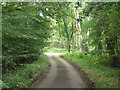
Lane towards Littleworth Road
The lane from the drive into the Hampton Estate forms a triangular junction here, this is the eastwards branch.
Image: © Robin Webster
Taken: 20 Jul 2012
0.10 miles
6
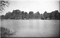
The Tarn, 1968
The lake, which is one of a sequence of five ponds providing the water to power Cut Mill and other mills, straddles an easting gridline, which crosses the little inlet opposite. On the far side is mixed woodland of pine and birch, behind which stretches Puttenham Common.
Image: © Derek Harper
Taken: Unknown
0.10 miles
7
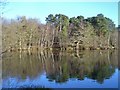
Puttenham Common - The Tarn
Dense woodland surrounds this old fishing pond near Puttenham.
Image: © Colin Smith
Taken: 2 Jan 2015
0.12 miles
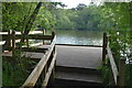
9
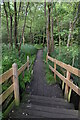
Boardwalk through marshy edges of The Tarn
Image: © David Martin
Taken: 3 Jun 2022
0.14 miles