IMAGES TAKEN NEAR TO
Hogs Back, FARNHAM, GU10 1HE
Introduction
This page details the photographs taken nearby to Hogs Back, GU10 1HE by members of the Geograph project.
The Geograph project started in 2005 with the aim of publishing, organising and preserving representative images for every square kilometre of Great Britain, Ireland and the Isle of Man.

There are currently over 7.5m images from over14,400 individuals and you can help contribute to the project by visiting https://www.geograph.org.uk
Image Map
Images are licensed for reuse under creativecommons.org/licenses/by-sa/2.0
Notes
- Clicking on the map will re-center to the selected point.
- The higher the marker number, the further away the image location is from the centre of the postcode.
Image Listing (7 Images Found)
Images are licensed for reuse under creativecommons.org/licenses/by-sa/2.0
Image
Details
Distance
2
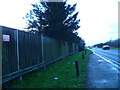
Westbound A31, Hog's Back
The crash barrier finishing on the left is to protect a police car stand, which does not seem to be much used.
Image: © Robin Webster
Taken: 20 Jul 2012
0.11 miles

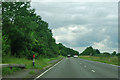
4
60 limit on the Hog's Back
The A31 here is a widely separated dual carriageway, but the several small access turnings with no or short acceleration lanes are the probable reason for the reduced speed limit.
Image: © Robin Webster
Taken: 20 Jul 2012
0.14 miles
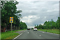
5
Hog's Back
Property just on the southern side of the A31 Hog's Back, the start of the North Downs.
Image: © Ben Gamble
Taken: 20 Nov 2005
0.20 miles
6
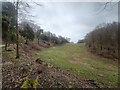
Totford Lane
View from the bend in the road on Stony Hill
Image: © James Emmans
Taken: 10 Mar 2021
0.22 miles
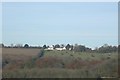
7
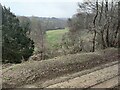
Cliff-like edge of Totford Lane
View toward Stoney Hill from the Hogs Back.
Image: © James Emmans
Taken: 10 Mar 2021
0.22 miles