IMAGES TAKEN NEAR TO
Hogs Back, FARNHAM, GU10 1HD
Introduction
This page details the photographs taken nearby to Hogs Back, GU10 1HD by members of the Geograph project.
The Geograph project started in 2005 with the aim of publishing, organising and preserving representative images for every square kilometre of Great Britain, Ireland and the Isle of Man.

There are currently over 7.5m images from over14,400 individuals and you can help contribute to the project by visiting https://www.geograph.org.uk
Image Map
Images are licensed for reuse under creativecommons.org/licenses/by-sa/2.0
Notes
- Clicking on the map will re-center to the selected point.
- The higher the marker number, the further away the image location is from the centre of the postcode.
Image Listing (32 Images Found)
Images are licensed for reuse under creativecommons.org/licenses/by-sa/2.0
Image
Details
Distance
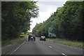
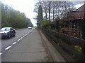
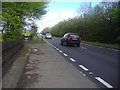
2
Westbound A31, Hog's Back
A right turn ahead, for Ash Green and Ash.
Image: © Robin Webster
Taken: 20 Jul 2012
0.03 miles
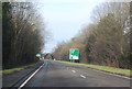
4
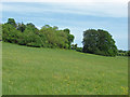
The Hog's Back ridge
Chalk downland on the south facing slope of the Hpg's Back.
Image: © Alan Hunt
Taken: 19 May 2014
0.08 miles
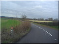
6
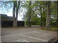
Squire's Holt car park
The restaurant has been here as long as I remember (over 20 years) but rarely appears to be open
Image: © David Howard
Taken: 7 May 2012
0.10 miles
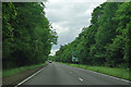
7
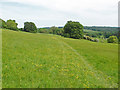
Downlands, Seale
The fields along the Hog's Back off Wood Lane are permissive entry.
Image: © Alan Hunt
Taken: 19 May 2014
0.10 miles
8
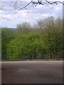
View from Squire's Holt restaurant car park
The North Downs begin around here and stretch across Kent to the east
Image: © David Howard
Taken: 7 May 2012
0.11 miles