IMAGES TAKEN NEAR TO
Old Bridge Road, FARNHAM, GU10 1FD
Introduction
This page details the photographs taken nearby to Old Bridge Road, GU10 1FD by members of the Geograph project.
The Geograph project started in 2005 with the aim of publishing, organising and preserving representative images for every square kilometre of Great Britain, Ireland and the Isle of Man.

There are currently over 7.5m images from over14,400 individuals and you can help contribute to the project by visiting https://www.geograph.org.uk
Image Map
Images are licensed for reuse under creativecommons.org/licenses/by-sa/2.0
Notes
- Clicking on the map will re-center to the selected point.
- The higher the marker number, the further away the image location is from the centre of the postcode.
Image Listing (42 Images Found)
Images are licensed for reuse under creativecommons.org/licenses/by-sa/2.0
Image
Details
Distance
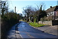
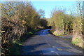
1
The end of Old Bridge Road
The vehicular right of way ends here and becomes a footpath. The road is clearly named as Old Bridge Road but is misidentified on Google Maps as St George's Road.
Image: © Shazz
Taken: 6 Mar 2011
0.04 miles
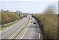
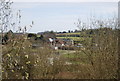
2
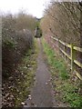
Truncated section of lane
Previously the lane from Runfold to Badshot Lea, now cut in half by the A31 dual carriageway.
Image: © David Martin
Taken: 1 Mar 2014
0.04 miles
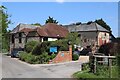
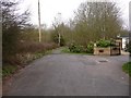
7
Footsteps
This long flight of steps leads to St George's Road.
Image: © Shazz
Taken: 6 Mar 2011
0.07 miles