IMAGES TAKEN NEAR TO
The Walled Garden, FARNHAM, GU10 1FA
Introduction
This page details the photographs taken nearby to The Walled Garden, GU10 1FA by members of the Geograph project.
The Geograph project started in 2005 with the aim of publishing, organising and preserving representative images for every square kilometre of Great Britain, Ireland and the Isle of Man.

There are currently over 7.5m images from over14,400 individuals and you can help contribute to the project by visiting https://www.geograph.org.uk
Image Map
Images are licensed for reuse under creativecommons.org/licenses/by-sa/2.0
Notes
- Clicking on the map will re-center to the selected point.
- The higher the marker number, the further away the image location is from the centre of the postcode.
Image Listing (54 Images Found)
Images are licensed for reuse under creativecommons.org/licenses/by-sa/2.0
Image
Details
Distance
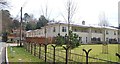
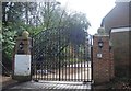
2
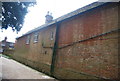
The Walled Garden, Moor Park
The Walled Garden is a housing development, located to the right of the original garden wall, in Moor Park. It overlooks the River Wey.
Image: © Peter Trimming
Taken: 11 Nov 2015
0.02 miles
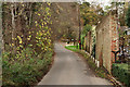
5
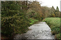
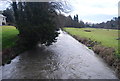
River Wey
Looking down river from Moor Park Lane.
Image: © Peter Trimming
Taken: 11 Nov 2015
0.03 miles
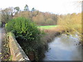
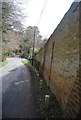
10
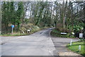
North Downs Way ahead, Greensand Way right
Image: © N Chadwick
Taken: 14 Apr 2013
0.04 miles