IMAGES TAKEN NEAR TO
North Side, The Cardinals, FARNHAM, GU10 1EB
Introduction
This page details the photographs taken nearby to North Side, The Cardinals, GU10 1EB by members of the Geograph project.
The Geograph project started in 2005 with the aim of publishing, organising and preserving representative images for every square kilometre of Great Britain, Ireland and the Isle of Man.

There are currently over 7.5m images from over14,400 individuals and you can help contribute to the project by visiting https://www.geograph.org.uk
Image Map
Images are licensed for reuse under creativecommons.org/licenses/by-sa/2.0
Notes
- Clicking on the map will re-center to the selected point.
- The higher the marker number, the further away the image location is from the centre of the postcode.
Image Listing (54 Images Found)
Images are licensed for reuse under creativecommons.org/licenses/by-sa/2.0
Image
Details
Distance
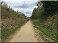
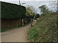
1
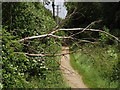
Branch Line?
A railway line once ran along the alignment of this footpath - built for goods traffic when nearby Aldershot Military Camp was under construction. A fallen tree obviously is now an impediment to walkers.
http://en.wikipedia.org/wiki/Tongham
Image: © Colin Smith
Taken: 16 Jun 2012
0.02 miles
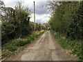
3
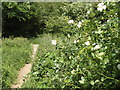
Footpath in Tongham
Wild roses blooming by the path where Tongham Railway Station once stood nearby. The railway existed here in Victorian times for construction traffic when Aldershot Military Camp was being built.
http://en.wikipedia.org/wiki/Tongham
Image: © Colin Smith
Taken: 16 Jun 2012
0.03 miles
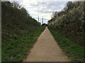
5
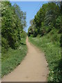
Disused railway, Tongham
A section of the disused railway bed, now used as a bridleway.
Image: © Alan Hunt
Taken: 25 Apr 2011
0.05 miles
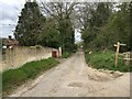
7
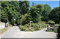
Footpath Junction, Spoil Lane
A more than usual number of footpaths and bridleways are shown on the map just here.
Some, like Spoil Lane, are residential lanes already, one is along an old railway, while others will vanish as footpaths when they are incorporated into urban streets as more houses are built.
Image: © Des Blenkinsopp
Taken: 10 Aug 2022
0.06 miles
8
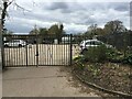
Access to Tongham allotments
Taken from the parish council website - "There are around 82 plots .... the gardens are a real haven of peace and tranquillity, with some plots holding beehives, some with chickens and the majority growing fruit, flowers and vegetables. There is a ‘loo’ and a communal area for sitting down and enjoying tea and cake."
Image: © Fernweh
Taken: 8 Apr 2021
0.06 miles