IMAGES TAKEN NEAR TO
Oxenden Road, FARNHAM, GU10 1AR
Introduction
This page details the photographs taken nearby to Oxenden Road, GU10 1AR by members of the Geograph project.
The Geograph project started in 2005 with the aim of publishing, organising and preserving representative images for every square kilometre of Great Britain, Ireland and the Isle of Man.

There are currently over 7.5m images from over14,400 individuals and you can help contribute to the project by visiting https://www.geograph.org.uk
Image Map
Images are licensed for reuse under creativecommons.org/licenses/by-sa/2.0
Notes
- Clicking on the map will re-center to the selected point.
- The higher the marker number, the further away the image location is from the centre of the postcode.
Image Listing (19 Images Found)
Images are licensed for reuse under creativecommons.org/licenses/by-sa/2.0
Image
Details
Distance
1
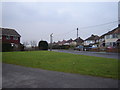
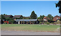
Carfax Avenue, Tongham
This avenue is triangular and has a tiny piece of green for the kids.
Image: © Graham Clutton
Taken: 6 Jan 2006
0.08 miles
2
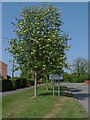
Ash, Manor Road
The signboard for Ash Parish with a very appropriate mountain ash alongside.
Image: © Alan Hunt
Taken: 25 Apr 2011
0.16 miles
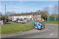
3
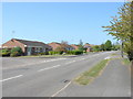
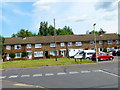
Tongham, Manor Road
Bungalows alongside Manor Road near the junction with Manor Close and Field Lane
Image: © Alan Hunt
Taken: 25 Apr 2011
0.17 miles
4
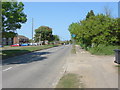
Ash, Manor Road
Looking north along Manor Road with Yeomans Close on the left, parallel with Manor Road.
Image: © Alan Hunt
Taken: 25 Apr 2011
0.17 miles
7
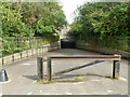
Subway under A331
This is decorated with high quality, possibly official, graffiti.
Image: © Robin Webster
Taken: 6 Aug 2015
0.18 miles
8
Footbridge, River Blackwater
The footbridge over the River Blackwater at the end of Tongham Road in Aldershot.
Image: © Alan Hunt
Taken: 25 Mar 2016
0.19 miles
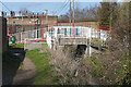
9
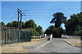
Bridge over the Blackwater
This leads to an underpass beneath the A331 and is blocked by bollards at the far end. I would guess it's for emergency vehicles only.
A small electricity sub station is on the left.
Image: © Des Blenkinsopp
Taken: 10 Aug 2022
0.19 miles
10
Willow Way, Aldershot
The willow Way junction with Tongham Road in this 1970s housing estate near Aldershot Park
Image: © Alan Hunt
Taken: 25 Mar 2016
0.19 miles