IMAGES TAKEN NEAR TO
Marshfield Road, BADMINTON, GL9 1JQ
Introduction
This page details the photographs taken nearby to Marshfield Road, GL9 1JQ by members of the Geograph project.
The Geograph project started in 2005 with the aim of publishing, organising and preserving representative images for every square kilometre of Great Britain, Ireland and the Isle of Man.

There are currently over 7.5m images from over14,400 individuals and you can help contribute to the project by visiting https://www.geograph.org.uk
Image Map
Images are licensed for reuse under creativecommons.org/licenses/by-sa/2.0
Notes
- Clicking on the map will re-center to the selected point.
- The higher the marker number, the further away the image location is from the centre of the postcode.
Image Listing (172 Images Found)
Images are licensed for reuse under creativecommons.org/licenses/by-sa/2.0
Image
Details
Distance
1
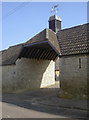
Cavendish Close
A modern development that was planned with regard to the village's character. See Image] for a closer look at the vane.
Image: © Neil Owen
Taken: 10 Oct 2018
0.01 miles
2
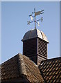
Weather vane on Cavendish Close
See Image] for a wider view of the stylish development.
Image: © Neil Owen
Taken: 10 Oct 2018
0.01 miles
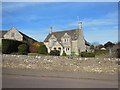
3
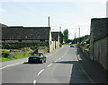
2009 : High Street, Tormarton
Tormarton in unfortunate in having to share one of its grid squares with a motorway bridge. Luckily the biggest part of the village is in the square next door Image so all is not lost.
This is the south eastern end of High Street, which goes to the top of the hill then becomes Marshfield Road.
Image: © Maurice Pullin
Taken: 8 Aug 2009
0.01 miles
4
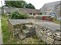
Milk churn stand
I'm fairly sure this is a former milk churn stand, rather than a mounting block for climbing on a horse.
Image: © Philip Halling
Taken: 1 Jul 2021
0.01 miles
5
The entrance to Cavendish Close, Tormarton
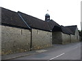
What was presumably an agricultural complex has been converted into housing.
Image: © David Purchase
Taken: 19 Sep 2013
0.01 miles
6
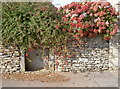
A flowery tap
A recessed feature in the wall appears to have been a water tap, but which sadly is now damaged.
Image: © Neil Owen
Taken: 10 Oct 2018
0.02 miles
7
Farm buildings at Tormarton
The barn at the back appears old and probably has had its original tiled, or Cotswold slate, roof replaced with asbestos corrugated sheets many years ago.
Image: © Philip Halling
Taken: 1 Jul 2021
0.02 miles
8
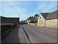
Marshfield Road Tormarton
The Cotswold Way, day five 8:33am
Image: © Ian S
Taken: 21 Apr 2013
0.02 miles
9
Houses on Marshfield Road, Tormarton
The Cotswold Way, day five 8:33am
Image: © Ian S
Taken: 21 Apr 2013
0.02 miles
10
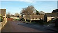
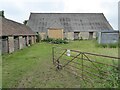
Marshfield Road, Tormarton
Looking towards the other side of the road from Image], with animal accommodation at Grange Farm.
Image: © Derek Harper
Taken: 14 Dec 2016
0.03 miles