IMAGES TAKEN NEAR TO
Hawkesbury Grange, BADMINTON, GL9 1EF
Introduction
This page details the photographs taken nearby to Hawkesbury Grange, GL9 1EF by members of the Geograph project.
The Geograph project started in 2005 with the aim of publishing, organising and preserving representative images for every square kilometre of Great Britain, Ireland and the Isle of Man.

There are currently over 7.5m images from over14,400 individuals and you can help contribute to the project by visiting https://www.geograph.org.uk
Image Map
Images are licensed for reuse under creativecommons.org/licenses/by-sa/2.0
Notes
- Clicking on the map will re-center to the selected point.
- The higher the marker number, the further away the image location is from the centre of the postcode.
Image Listing (46 Images Found)
Images are licensed for reuse under creativecommons.org/licenses/by-sa/2.0
Image
Details
Distance
1
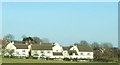
Houses seen across the field
The rear of houses situated at the end of a cul-de-sac at the eastern edge of Hawkesbury Upton. All of the homes in this row have views southwards across open fields.
Image: © Ruth Riddle
Taken: 25 Feb 2012
0.04 miles
2
Old Milestone, France Lane
In the parish of Hawkesbury, in the village of Hawkesbury Upton. NW side of road, embedded in the earth bank. Mileage is measured to Wotton under Edge. Rivet Benchmark on top, 176.7 m ASL.
Inscription (was): Wotton 5
Milestone Society ID: GL_WEHU05
Image: © Mr Red
Taken: 21 Oct 2021
0.05 miles
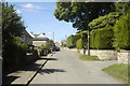
3
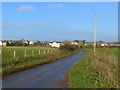
Looking north towards Hawkesbury Upton
Image: © Ruth Sharville
Taken: 29 Nov 2014
0.15 miles
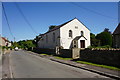
4
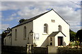
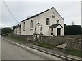
Baptist Chapel, Park Street, Hawkesbury Upton, Gloucestershire 2013
Chapel dated 1844.
Image: © Ray Bird
Taken: Unknown
0.16 miles
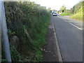
5
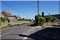
France Lane, Hawkesbury Upton
The main connection with the A46, viewed at its junction with Sandpits Lane.
Image: © Bill Boaden
Taken: 19 Jul 2016
0.16 miles
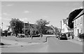
6
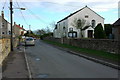
Park Street, Hawkesbury Upton, Gloucestershire 2013
Image: © Ray Bird
Taken: Unknown
0.16 miles
7
Bethesda Chapel, Hawkesbury Upton
A still active independent church within the Congregational Federation. The inscription dates the building from 1844.
Image: © Bill Boaden
Taken: 19 Jul 2016
0.17 miles
8
The Plain, Hawkesbury Upton, Gloucestershire 2013
Village Green, The Plain.
Image: © Ray Bird
Taken: Unknown
0.18 miles
10
Bethesda Chapel, Hawkesbury Upton
The chapel dated from 1844.
Image: © Philip Halling
Taken: 14 Jan 2007
0.18 miles