IMAGES TAKEN NEAR TO
The Street, BADMINTON, GL9 1DS
Introduction
This page details the photographs taken nearby to The Street, GL9 1DS by members of the Geograph project.
The Geograph project started in 2005 with the aim of publishing, organising and preserving representative images for every square kilometre of Great Britain, Ireland and the Isle of Man.

There are currently over 7.5m images from over14,400 individuals and you can help contribute to the project by visiting https://www.geograph.org.uk
Image Map
Images are licensed for reuse under creativecommons.org/licenses/by-sa/2.0
Notes
- Clicking on the map will re-center to the selected point.
- The higher the marker number, the further away the image location is from the centre of the postcode.
Image Listing (124 Images Found)
Images are licensed for reuse under creativecommons.org/licenses/by-sa/2.0
Image
Details
Distance
1
The Reading Room
As Didmarton grew this building was constructed in the early 1900s. It served as a reading room, village hall and community centre before becoming a private concern. Grade II listed.
Image: © Neil Owen
Taken: 31 Mar 2021
0.01 miles
2
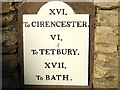
Old Milestone by the A433, Didmarton
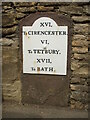
Metal plate attached to stone post by the A433, in parish of DIDMARTON (COTSWOLD District), Didmarton, 9m West of No. 34, by the road, on North side of road. Cirencester Roman iron plate, erected by the Cirencester & Bath turnpike trust in the 19th century.
Inscription reads:-
XVI.
To CIRENCESTER.
VI.
To TETBURY.
XVII.
To BATH.
Grade II listed. List Entry Number: 1341186
https://historicengland.org.uk/listing/the-list/list-entry/1341186
Milestone Society National ID: GL_CIBA16.
Image: © JM Weightmann
Taken: 1 Oct 2000
0.02 miles
3
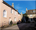
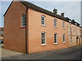
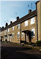
Chapel Walk houses, Didmarton
Located on the north side of The Street (the A433), the main road through the village.
Image: © Jaggery
Taken: 13 Jan 2013
0.02 miles
4
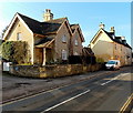
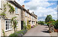
Didmarton houses
Houses on the south side of The Street, the local name for the A433, the main road through the village.
Image: © Jaggery
Taken: 13 Jan 2013
0.02 miles
5
Roman miles away
The milestone in Didmarton had a bit of a refresh a while ago and the rust is beginning to reappear. Interestingly, the mileage is in Roman numerals.
Image: © Neil Owen
Taken: 31 Mar 2021
0.02 miles
6
An example of triskaidekaphobia, Didmarton
Part of the numbering sequence of these Chapel Walk houses is 15, 11A, 11.
The absence of number 13 is an example of triskaidekaphobia,
a fear of (using) the number 13, based on the superstition that the number brings bad luck.
Image: © Jaggery
Taken: 13 Jan 2013
0.02 miles
7
Chapel Walk, Didmarton, Gloucestershire 2014
Image: © Ray Bird
Taken: 7 Jul 2014
0.02 miles
8

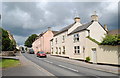
Houses in Didmarton
These old stone houses on The Street in Didmarton have been rendered but the render is decaying, as with much of the fabric of these unrenovated buildings that once housed agricultural workers.
Image: © Nigel Mykura
Taken: 8 Jul 2012
0.03 miles
9
The Street, Didmarton, Gloucestershire 2014
Image: © Ray Bird
Taken: 7 Jul 2014
0.03 miles
10

Chapel Walk, Didmarton
This passageway leads to a footpath over fields to Oldbury-on-the-Hill.
Image: © Mike Baldwin
Taken: 15 Aug 2009
0.03 miles