IMAGES TAKEN NEAR TO
Hawkesbury Upton, BADMINTON, GL9 1AQ
Introduction
This page details the photographs taken nearby to GL9 1AQ by members of the Geograph project.
The Geograph project started in 2005 with the aim of publishing, organising and preserving representative images for every square kilometre of Great Britain, Ireland and the Isle of Man.

There are currently over 7.5m images from over14,400 individuals and you can help contribute to the project by visiting https://www.geograph.org.uk
Image Map
Images are licensed for reuse under creativecommons.org/licenses/by-sa/2.0
Notes
- Clicking on the map will re-center to the selected point.
- The higher the marker number, the further away the image location is from the centre of the postcode.
Image Listing (3 Images Found)
Images are licensed for reuse under creativecommons.org/licenses/by-sa/2.0
Image
Details
Distance
1
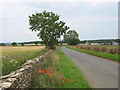
Beech Lane
Beech Lane Farm is ahead, on the right.
Image: © David Purchase
Taken: 3 Jul 2011
0.03 miles
2
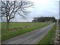
Beech Lane and Starveall
Located half way along the minor road, linking the A46 with the A433.
Image: © Roger Cornfoot
Taken: 1 Feb 2007
0.13 miles
3
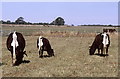
Gloucester Cattle, nr Didmarton, Gloucestershire 2003
Rare Breeds Gloucester Cattle.
Image: © Ray Bird
Taken: Unknown
0.23 miles