IMAGES TAKEN NEAR TO
Hawkesbury Upton, BADMINTON, GL9 1AE
Introduction
This page details the photographs taken nearby to GL9 1AE by members of the Geograph project.
The Geograph project started in 2005 with the aim of publishing, organising and preserving representative images for every square kilometre of Great Britain, Ireland and the Isle of Man.

There are currently over 7.5m images from over14,400 individuals and you can help contribute to the project by visiting https://www.geograph.org.uk
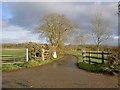
Image Map
Images are licensed for reuse under creativecommons.org/licenses/by-sa/2.0
Notes
- Clicking on the map will re-center to the selected point.
- The higher the marker number, the further away the image location is from the centre of the postcode.
Image Listing (3 Images Found)
Images are licensed for reuse under creativecommons.org/licenses/by-sa/2.0
Image
Details
Distance
1
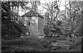
Former Pump House, nr Little Badminton, Gloucestershire 2013
Former Water Pump & Pond that served Swangrove House, Swangrove Wood, nr Little Badminton, Gloucestershire 2013.
Grade 2 listed. Dated Early-mid 19th Century
Image: © Ray Bird
Taken: 30 Oct 2013
0.11 miles
2
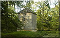
Former Pump House, nr Little Badminton, Gloucestershire 2013
Former Water Pump House & Pond for Swangrove House, Swangrove Wood, nr Little Badminton, Gloucestershire 2013.
Grade 2 Listed. Dated early-mid 19th Century.
Image: © Ray Bird
Taken: 30 Oct 2013
0.11 miles