IMAGES TAKEN NEAR TO
Kingscote, TETBURY, GL8 8YE
Introduction
This page details the photographs taken nearby to GL8 8YE by members of the Geograph project.
The Geograph project started in 2005 with the aim of publishing, organising and preserving representative images for every square kilometre of Great Britain, Ireland and the Isle of Man.

There are currently over 7.5m images from over14,400 individuals and you can help contribute to the project by visiting https://www.geograph.org.uk
Image Map
Images are licensed for reuse under creativecommons.org/licenses/by-sa/2.0
Notes
- Clicking on the map will re-center to the selected point.
- The higher the marker number, the further away the image location is from the centre of the postcode.
Image Listing (6 Images Found)
Images are licensed for reuse under creativecommons.org/licenses/by-sa/2.0
Image
Details
Distance
2
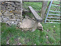
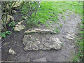
Stone Stile, Kingscote
A "fallen idle". The remnant of a vertical slab stile re-purposed as a step on Gloucestershire footpath NKS3, near Kingscote Barn and Binley Farm Cottages looking NE. the view SW is Image
Image: © Mr Red
Taken: 3 Feb 2022
0.11 miles
3
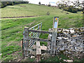
Stone Stile, Kingscote
A "fallen idle". The remnant of a vertical slab stile re-purposed as a step on Gloucestershire footpath NKS3, near Kingscote Barn and Binley Farm Cottages looking SW. The view NE is Image
Image: © Jayne Tovey
Taken: 11 Oct 2022
0.11 miles
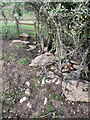
5
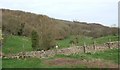
Stone Stile, Kingscote
A "fallen idle". Remnant of a stone stile at the end of a former wall on Gloucestershire footpaths NKS3 & NKS5. Between Kingscote & Kingscote Barn looking South, the view North is Image
Image: © Mr Red
Taken: 3 Feb 2022
0.21 miles
6
Stone Stile, Kingscote
A "fallen idle". Remnant of a stone stile at the end of a former wall on Gloucestershire footpaths NKS3 & NKS5. Between Kingscote & Kingscote Barn looking North, the view South is Image
Image: © Jayne Tovey
Taken: 11 Oct 2022
0.21 miles