IMAGES TAKEN NEAR TO
Cherington, TETBURY, GL8 8SJ
Introduction
This page details the photographs taken nearby to GL8 8SJ by members of the Geograph project.
The Geograph project started in 2005 with the aim of publishing, organising and preserving representative images for every square kilometre of Great Britain, Ireland and the Isle of Man.

There are currently over 7.5m images from over14,400 individuals and you can help contribute to the project by visiting https://www.geograph.org.uk
Image Map
Images are licensed for reuse under creativecommons.org/licenses/by-sa/2.0
Notes
- Clicking on the map will re-center to the selected point.
- The higher the marker number, the further away the image location is from the centre of the postcode.
Image Listing (7 Images Found)
Images are licensed for reuse under creativecommons.org/licenses/by-sa/2.0
Image
Details
Distance
1
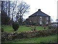
Yewtree cottages
An isolated building, housing several dwellings, on the minor road, between Culkerton and Cherington.
Image: © Roger Cornfoot
Taken: 12 Feb 2007
0.02 miles
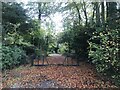
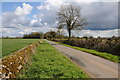
4
Road through Yewtree Plantation
Road through Yewtree Plantation to the south of Cherington.
Image: © Philip Halling
Taken: 21 Apr 2012
0.13 miles
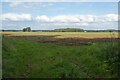
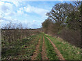
5
Road near Yewtree Plantation
Country road to the south of Cherington where it approaches Yewtree Plantation.
Image: © Philip Halling
Taken: 21 Apr 2012
0.15 miles
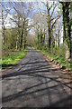
7

Country road towards Yewtree Cottages
Image: © Vieve Forward
Taken: 15 Mar 2021
0.24 miles