IMAGES TAKEN NEAR TO
Avening, TETBURY, GL8 8NY
Introduction
This page details the photographs taken nearby to GL8 8NY by members of the Geograph project.
The Geograph project started in 2005 with the aim of publishing, organising and preserving representative images for every square kilometre of Great Britain, Ireland and the Isle of Man.

There are currently over 7.5m images from over14,400 individuals and you can help contribute to the project by visiting https://www.geograph.org.uk
Image Map
Images are licensed for reuse under creativecommons.org/licenses/by-sa/2.0
Notes
- Clicking on the map will re-center to the selected point.
- The higher the marker number, the further away the image location is from the centre of the postcode.
Image Listing (18 Images Found)
Images are licensed for reuse under creativecommons.org/licenses/by-sa/2.0
Image
Details
Distance
1
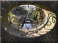
Ornately framed picture of the stream at Avening Court
Image: © don cload
Taken: 26 Feb 2019
0.03 miles
2
From Hampton Fields to watch your step - Avening, Gloucestershire
This is the southern end of the public footpath which runs from south of Hampton Fields Image to end here on the lane between Avening Image and Nags Head Image A place where you really have to watch your step on a dark night or at any time for that matter. Time photo taken not available.
Image
Image
Image: © Martin Richard Phelan
Taken: Unknown
0.06 miles
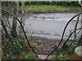
3
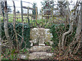
Unusual stile
Note the rather appropriate improvement to the step from the old photo at https://www.geograph.org.uk/photo/5896754
Image: © don cload
Taken: 26 Feb 2019
0.06 miles
4
Stone Stile, Mays Lane, Avening
Still in Avening this step stile is fully the height of the wall. It looks North from May Lane. The view looking to the road is Image
Image: © Mr Red
Taken: 17 Dec 2021
0.06 miles
5
Stone Stile, Mays Lane, Avening
Still in Avening this step stile is fully the height of the wall. It looks North from May Lane. The view looking to the road is Image
Image: © Mr Red
Taken: 17 Dec 2021
0.06 miles
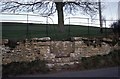
6
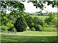
Wobbly fence to the river
Grazing land south of the minor road from Nags Head to Avening.
Image: © Graham Horn
Taken: 30 Apr 2007
0.09 miles

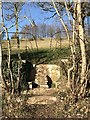
8
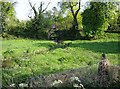
Stream through the edge of Avening
The stream from Cherington Pond grows quickly and by the time it has reached Avening just over a mile away it is this big, with the obvious potential to flood much more in winter, judging by the flood plain and the size of the bridge. The minor road into Avening from the east crosses the stream on this bridge, being used by a tractor.
Image: © Graham Horn
Taken: 30 Apr 2007
0.17 miles
9
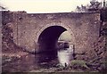
Road bridge over river
Bridge after some restoration involving cleaning of ivy and trees rebuilding stonework and re pointing the arch by yours truly and colleagues from GCC highways.
Image: © norman hyett
Taken: 29 Jan 1984
0.18 miles
10
Stone Stile, Minchinhampton Golf Course
In the middle of the golf course on Gloucestershire footpath NAV22. The alternative view looking South is Image
Image: © Jayne Tovey
Taken: 2 Feb 2023
0.18 miles