IMAGES TAKEN NEAR TO
Star Lane, TETBURY, GL8 8NT
Introduction
This page details the photographs taken nearby to Star Lane, GL8 8NT by members of the Geograph project.
The Geograph project started in 2005 with the aim of publishing, organising and preserving representative images for every square kilometre of Great Britain, Ireland and the Isle of Man.

There are currently over 7.5m images from over14,400 individuals and you can help contribute to the project by visiting https://www.geograph.org.uk
Image Map
Images are licensed for reuse under creativecommons.org/licenses/by-sa/2.0
Notes
- Clicking on the map will re-center to the selected point.
- The higher the marker number, the further away the image location is from the centre of the postcode.
Image Listing (27 Images Found)
Images are licensed for reuse under creativecommons.org/licenses/by-sa/2.0
Image
Details
Distance
1

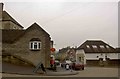
Star Lane, Avening
On the left is the Cross Inn
Image: © David Smith
Taken: 8 Jun 2018
0.04 miles
2
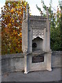
Memorial to William Fowles, Avening
The memorial is situated on a sharp bend in the centre of the village.
The memorial reads as follows:
WILLIAM FOWLES
1835-1896
This to his memory
by
those amongst whom he lived
and
who knew his worth
Image: © Philip Halling
Taken: 29 Oct 2006
0.05 miles
3

Avening
The Cross Inn is located on the sharp bend in the middle of the village.
Image: © Philip Halling
Taken: 29 Oct 2006
0.05 miles
4
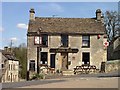
The Cross Inn Avening
The Cross Inn Avening
Researched links
http://pubshistory.com/Gloucestershire/Cirencester/index.shtml
http://www.gloucestershirepubs.co.uk/FeatureFiller/index.php
Image: © Paul Best
Taken: 15 Apr 2013
0.05 miles
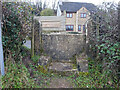
5
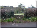
Stone Stile, Avening
Off Star Lane on a footpath running down to Mays Lane. Looking NE, the other view SW is Image
Image: © Mr Red
Taken: 20 Dec 2021
0.05 miles
6
Stone Stile, Avening
Off Star Lane on a footpath running down to Mays Lane. Looking SW, the other view NE is Image
Image: © Mr Red
Taken: 20 Dec 2021
0.05 miles
7

Direction Sign ? Signpost
Located fixed to the side of a house on the east side of the junction of the B4014 Tetbury Hill and Star Lane at ground floor level in Avening parish. 1 arm. See also https://www.geograph.org.uk/photo/269650.
Milestone Society National ID: GL_ST8897
Image: © S Kosciow
Taken: 7 Jun 2020
0.06 miles
8
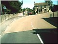
Sharp turn in the road
In Avening. The B4014 turns nearly 180 degrees here, and climbs a 1 in 10 hill once round the bend. The road ahead goes to Mincninhampton. The building in the picture is the Crown Inn.
Image: © andrew auger
Taken: 10 Sep 2009
0.07 miles
9
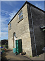
Avening Baptist Church
Now a private house.
Image: © Vieve Forward
Taken: 9 Mar 2017
0.08 miles