
IMAGES TAKEN NEAR TO
Old Hill, TETBURY, GL8 8NR
Introduction
This page details the photographs taken nearby to Old Hill, GL8 8NR by members of the Geograph project.
The Geograph project started in 2005 with the aim of publishing, organising and preserving representative images for every square kilometre of Great Britain, Ireland and the Isle of Man.

There are currently over 7.5m images from over14,400 individuals and you can help contribute to the project by visiting https://www.geograph.org.uk
Image Map
Images are licensed for reuse under creativecommons.org/licenses/by-sa/2.0
Notes
- Clicking on the map will re-center to the selected point.
- The higher the marker number, the further away the image location is from the centre of the postcode.
Image Listing (24 Images Found)
Images are licensed for reuse under creativecommons.org/licenses/by-sa/2.0
Image
Details
Distance
1
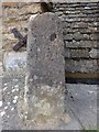
Old Boundary Marker by Powis Lane, Avening
Boundary Marker by the UC road, in parish of Avening (Cotswold District), Powis Lane, historically known as Mount Pleasant. The stone is also considered to be a milestone, or a Turnpike staging post. The inscription was re-carved after a survey in 1999 - see link.
Inscription reads:-
Aveneing
1721
Gloucestershire CC HER.
HER reference: 2987 https://www.heritagegateway.org.uk/Gateway/Results_Single.aspx?uid=2987&resourceID=108
Surveyed
Milestone Society National ID: GL_AVEN01bm
Image: © Milestone Society
Taken: Unknown
0.04 miles
2
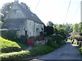
Old Hill, Avening
Old Hill, old cottage, nearly a timeless scene. Except for the telephone lines, the garden umbrella, the tarmac on the road...
Image: © Graham Horn
Taken: 1 May 2007
0.04 miles
3

Rectory Lane, Avening
Contrasting house styles in Rectory Lane, whitewashed versus natural stone.
Image: © Graham Horn
Taken: 1 May 2007
0.07 miles
4
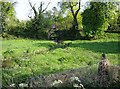
Stream through the edge of Avening
The stream from Cherington Pond grows quickly and by the time it has reached Avening just over a mile away it is this big, with the obvious potential to flood much more in winter, judging by the flood plain and the size of the bridge. The minor road into Avening from the east crosses the stream on this bridge, being used by a tractor.
Image: © Graham Horn
Taken: 30 Apr 2007
0.12 miles
5
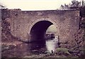
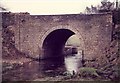
Road bridge over river
Bridge after some restoration involving cleaning of ivy and trees rebuilding stonework and re pointing the arch by yours truly and colleagues from GCC highways.
Image: © norman hyett
Taken: 29 Jan 1984
0.14 miles
7
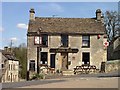
The Cross Inn Avening
The Cross Inn Avening
Researched links
http://pubshistory.com/Gloucestershire/Cirencester/index.shtml
http://www.gloucestershirepubs.co.uk/FeatureFiller/index.php
Image: © Paul Best
Taken: 15 Apr 2013
0.15 miles
8

Direction Sign ? Signpost
Located fixed to the side of a house on the east side of the junction of the B4014 Tetbury Hill and Star Lane at ground floor level in Avening parish. 1 arm. See also https://www.geograph.org.uk/photo/269650.
Milestone Society National ID: GL_ST8897
Image: © S Kosciow
Taken: 7 Jun 2020
0.15 miles
9

Star Lane, Avening
On the left is the Cross Inn
Image: © David Smith
Taken: 8 Jun 2018
0.16 miles
10

Avening
The Cross Inn is located on the sharp bend in the middle of the village.
Image: © Philip Halling
Taken: 29 Oct 2006
0.17 miles